

NavVis VLX - Mobile Mapping System
NavVis VLX is a mobile mapping system designed for laser scanning and AEC professionals that enables high-quality \ capture of complex buildings and construction sites.
The software makes the difference Dynamic scanning Versatility when you need it most. Up to 10 times faster than a terrestrial laser scanner, NavVis VLX 2nd generation can tackle anything from complex indoor spaces with challenging light conditions to outdoor environments and Superb accuracy construction sites. For accuracy that exceeds industry standards, NavVis VLX is powered by precision SLAM technology that`s entirely in a class of its own.
The hardware makes it even better
All-in-one reality capture
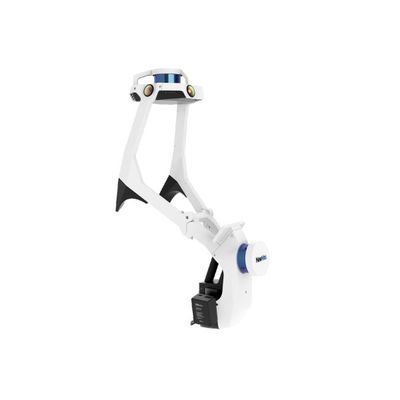
Capture 3D measurements with two multi-layer LiDAR sensors in combination with industry-leading SLAM software to deliver survey-grade point cloud quality. Four cameras positioned on top of the device take high resolution images in every direction for complete 360° capture — all without the operator appearing in the field of view.
Live mapping feedback
Monitor your scanning progress in real time with a built-in touchscreen interface, to ensure complete coverage as you move.
Precision meets ergonomics
A first-of-its-kind wearable device which enables operators to comfortably scan at the speed of walking. The forward-facing design allows for targeted scanning, together with a built-in screen for optimal viewing.
- Grip pads
- Shoulder pads
- Built-in screen
- Forward-facing design
- Stabilizing belt
Geo-registration
NavVis VLX is fully compatible with standard tools in the field. It can capture control points in a local site coordinate system measured by Total Stations and GNSS rovers, and also supports national and global coordinates for precise geo-registration and alignment of datasets.
Folding design
The unique hinged design folds up and fits into a protective case, so that a single operator can easily transport and set up.