

- Home
- Companies
- Infinite Jib Inc
- Products
- Nexus - Model 800 - LiDAR / ...
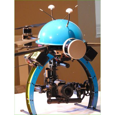
Nexus - Model 800 -LiDAR / Photogrammetry Unmanned Aerial System
The full end-to-end solution that represents a new paradigm in UAV data collection by seamlessly harmonizing LiDAR data with photogrammetry. The Nexus 800 is a turnkey system that tightly integrates hardware and software to provide a cutting-edge solution for LiDAR survey planning, data acquisition, post processing and analysis, and product creation.
Its foundation is built upon the underlying principle of turning data into tangible information by leveraging the power of real time sensor fusion. Marrying LiDAR sensing and photogrammetry simultaneously limits the “dead time” by streamlining the process of transforming data to meaningful models of the landscape.
Once all the necessary data has been acquired from a flight, Hypack software is utilized to rapidly process it. The software automatically registers any spatially referenced images to build a 3D model, which can then be exported into several different formats as required.
The NEXUS 800 UAS is highly effective in applications where turn around time is paramount such as:
- When you need to see real time data quality
- When you need to see how much coverage you are attaining
- When you want to minimize post processing time
- When you need continuous operations and better situational awareness
- When you need actionable intelligence as soon as possible
Designed and supported by best of brands
Designed and supported by: Infinite Jib™ Inc., HYPACK, a Xylem Brand, SBG Systems, and Velodyne LiDAR.
The Nexus 800 UAS payload includes:
- Velodyne Puck Lite (16 Channel)
- FLIR Vue Pro Thermal Camera
- SBG Ellipse-D Dual GNSS Inertial Navigation System
- RGB Camera
- HYPACK/HYSWEEP
- Hi-performance on-board computing with the Intel
- Core i7 16GB RAM/512GB