

- Home
- Companies
- Novatest S.r.l.
- Products
- Novatest - Model UAV mdLiDAR - Drone
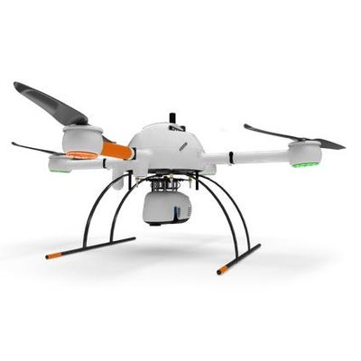
Novatest - Model UAV mdLiDAR -Drone
Work smarter with Microdrones drone surveying products. HERE’S HOW TO MAKE DRONES A PART OF YOUR SURVEYING, MAPPING, LIDAR AND INSPECTION WORK. Want to create powerful data deliverables like 3D pointclouds or orthomosaics? Microdrones Integrated Systems help you to collect data efficiently and safely while cutting costs, saving time, and converting data into useful information. We currently offer three families of solutions that will improve your workflow for LiDAR, photogrammetry and inspection projects.
mdLiDAR. Complete UAV LiDAR Mapping and Surveying packages
Plan, fly, process and visualize. mdLiDAR solutions are fully integrated packages that provide professionals with the aircraft, payload, software and support needed to quickly and reliably generate pointcloud visualizations in the field.
mdLiDAR1000UHR and mdLiDAR1000HR are fully integrated systems for producing 3D pointclouds optimized for land surveying, construction, oil & gas, and mining applications. A fully integrated software workflow and world class support help users consistently provide quality deliverables.
mdLiDAR1000UHR: THE BEST LIDAR POINT DENSITY AND DATA QUALITY
mdLiDAR1000UHR means ultra-high resolution via a 32-channel LiDAR sensor, fully integrated with an improved 72.5° field of view camera. This translates to more point density, better detail, and improved deliverables. The survey equipment, LP360 Drone software, workflow, training, and support work together to make you more productive than ever.
Don’t need the full resolution of 32-channel UHR? We offer a cost competitive UHR Lite configuration, delivering 16 channels of LiDAR that can easily be upgraded later via a firmware update.
LiDAR SURVEY EQUIPMENT + LP360 DRONE = EXTREME GEOSPATIAL PRODUCTIVITY, NOW IN ULTRA HIGH RESOLUTION
Microdrones has developed an end-to-end LiDAR solution combining a drone, a LiDAR payload, a fully integrated LiDAR processing and photogrammetry software workflow, and world class support to consistently provide quality deliverables.
mdLiDAR1000UHR and UHR Lite is a fully integrated system for producing 3D pointclouds optimized for land surveying, construction, oil & gas and mining applications.
Improved image acquisition precisely configured to match the laser scanner field of view enables compatibility with streamlined data processing modules within LP360. .
Each LiDAR channel of the mdLiDAR1000UHR and UHR Lite is boresight calibrated to improve the data consistency, therefore providing a reduced Standard Measurement Uncertainty.