

- Home
- Companies
- Ionosphere Monitoring and Prediction ...
- Products
- One hour Forecast TEC Map, Europe
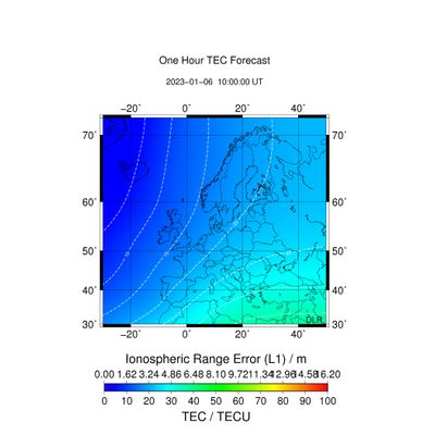
One hour Forecast TEC Map, Europe
Specification: Description
External parties: German Federal Agency for Cartography and Geodesy, data providers below
Data providers: EUREF, ASI
Input data: GPS dual-frequency measurements
Input sampling rates: 1 s
Reliability of data source: Data is preprocessed by DLR including e.g. cycle slip detection
Region of sensors: Global - Used stations for TEC map generation are listed in the
Sensors: cf. station list
Single layer shell height: 400 km
Spatial resolution: 2° Latitude x 2° Longitude
Boundaries of grid: 30°N – 72°N, 30°W – 50°E
Temporal resolution: 15 min
Time information: UTC Time
Reference coordinate system: ECEF coordinate system with WGS84 reference ellipsoid
Algorithms: 2The one hour forecast is calculated as a sum of the actual European TEC map and a weighted sum of the temporal TEC gradient of the previous hour and the temporal gradient of the previous day at the same time.
File format: ASCII
ASCII file format: Header line containing: unit of TEC values, UTC time, minimum latitude in degree, maximum latitude in degree, minimum longitude in degree, maximum longitude in degree, latitude step width in degree, longitude step width in degree, size of data matrix
Data matrix with VTEC values in TECU (1e+16 electrons/m²):Upper left corner value represents the minimum longitude and maximum latitude; the lower right corner value represents the maximum longitude and minimum latitude value
Error of the NRT TEC map for Europe, derived from errors of the GNSS measurements.