

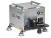
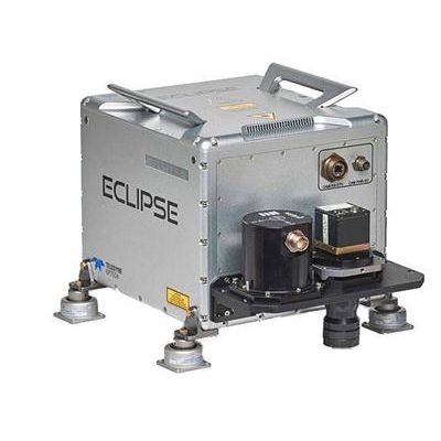
Optech Eclipse - Autonomous Lidar and Imagery Data Collection System
The Optech Eclipse is the first autonomous airborne system to focus on operator-less data collection from tightly integrated passive and active imaging sensors on low-cost platforms. Designed specifically for the efficient data collection of smaller project areas and corridor applications, the Eclipse requires only a pilot for navigation.
The Eclipse combines an eye-safe, high-performance, 1.5-micron laser with a high-accuracy automatic imaging system for effortless collection of high-resolution lidar data and imagery via its innovative sensor motion detection system. Simply press the power button and the sensor automatically starts collecting data when the sensor is in motion. A small dash-mounted status bar feeds sensor status information to the pilot with LEDs and incorporates a simple switch to start recording data. Lidar and image data are simultaneously captured on a single high-capacity removable SSD cartridge for fast and efficient data transfer to Optech Lidar Mapping Suite (LMS).
LMS includes both lidar and image pre-processing within a single workflow, and employs robust least-squares algorithms to auto-calibrate lidar data and perform photogrammetric block adjustments. Relative and absolute accuracies are then quantified and data is output in a variety of formats. Included is a flight planning tool that leverages a digital globe for 3D planning purposes and generates flightline waypoints for direct ingestion into 3rd-party navigation systems.
- Fully autonomous airborne collection system for operator-less data collection on low-cost platforms
- Automatic data logging using a proprietary sensor motion detection system
- Completely integrated active and passive imaging system that simultaneously records high-resolution image data to the same removable drive as the lidar data
- Class 1 eye-safe laser for freedom of operation in all environments
- Survey-grade accuracy with Teledyne Optech’s industry-leading measurement precision and an integrated Applanix OEM POS AV system
- Minimum of 4 points/m2 from 1000 m (3300 ft.) AGL
- Up to 7 returns per shot for improved vertical density
- Continuous Multipulse technology enables continuous coverage across PIA blind zones for high-density sampling in varied terrain
- Fully electronic camera with no moving parts eliminates the need for periodic shutter replacement
- Rotating polygon scanner for parallel scan lines and even point distribution
- Intuitive and simple planning software with integrated digital globe map engine
- Single unified workflow that downloads, calibrates, boresights, qualifies, quantifies and outputs both lidar and raw image datasets
- No operational training required
- Small-area surveying
- Powerline mapping
- Pipeline monitoring
- Construction site monitoring
- Mine monitoring
- Stockpile surveying
- Archaeology and cultural heritage documentation