

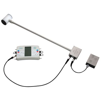
GEODEVICE - Model MaxiMag -Overhauser walking magnetometer-gradiometer
Flexible Configurations for Any Survey
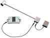
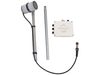
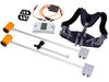
MaxiMag console permits connecting up to 30 digital Overhauser sensors or SmartMag magnetometers via a wired CAN interface. It makes it easy to build two- or multi-sensor gradiometers with any measurement base and any console-to-sensor distance.
Optional brackets and frames for any scenarios
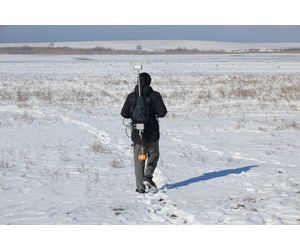
- Brackets for carrying two sensors in hand or in a backpack harness
- Multi-sensor frame for cross-country and shallow water archaeology
- Cart for multi-sensor gradiometer
- Sled for magnetometer and multi-sensor gradiometer
Easy to Use in the Field
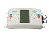
The tablet-style console features a large heated daylight-readable display, two-way keypad and an LED flashlight.
A built-in multi-band GNSS receiver provides line planning, navigation, coordinates and timestamps.
Supports external GNSS via NMEA-0183.
Data download via USB, RS-232 or industrial microSD.
All components are non-magnetic.
Suitable for Magnetic Observatories
High sensitivity and accuracy (better than 0.1 nT) allow MaxiMag and SmartMag / OVHmag sensors to be used in magnetic observatories and INTERMAGNET networks.
Real-time broadcasting over CAN FD or RS-232, CAN line length up to several kilometers.
Optional CAN-Ethernet module.
Delivered with SmartManager software.
Sensor Variants
Modular – convenient for transport and warm climates
Rigid – best for harsh low-temperature field conditions
Power & Autonomy
Included Li-ion battery provides:
11+ hours at −30°C
17+ hours at +20°C
Supported continuous power sources: car battery, AC-DC converter (110/220VAC → 12VDC), or solar panel.
No built-in sealed batteries → easy and safe air transport.
Data Format
Data is organized into project folders. Each survey session is saved as a TXT file named by console serial number, measurement mode, and number of sensors.
Each measurement is recorded as one structured line containing UTC time, line / station name, total field + estimated error, sensor ID, latitude / longitude, altitude + UTM (auto zone), and GNSS accuracy.
In gradiometer mode, the same file format is kept — the line simply includes values for each connected sensor.
This guarantees clean, consistent datasets and makes it easy to identify which instrument and operator collected each measurement.
Accuracy in Real Environments
Each sensor undergoes metrological testing (noise level, absolute accuracy, heading error).
Advanced noise filters allow operation in cities and under powerlines.
Reliability & Support
3-year warranty
Overhauser sensors have >10-year lifetime
Trade-in program available
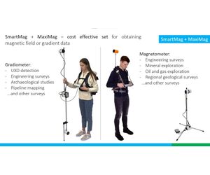
Applications
Mineral exploration • Regional geology • Engineering surveys • Pipeline mapping • UXO detection • Archaeology • Oil & gas • Magnetic observatories
Type: Overhauser magnetometer
Number of sensors: up to 30
Dynamic range: 20 000 to 120 000 nT
Absolute accuracy: 0.1 nT
Sensor sensitivity: 0.021 nT/√Hz rms or 0.012 nT/√Hz rms (on request)
Resolution: 0.001 nT
Gradient tolerance: 30 000 nT/m
Sample rates: 0.2, 0.25, 0.5, 1, 2, 3 s and longer with 1 s step
Sensors stability: > 10 years
Interfaces: Built-in: USB, RS-232, CAN FD. Optional: Ethernet (CAN-Ethernet interface module)
Maximum communication cable length: up to 6 km (CAN FD), up to 100 m (RS-232)
GNSS receiver: built-in and optional external
GNSS antenna: built-in and optional external
GNSS signals: GPS L1C/A and L2C; GLONASS L1OF and L2OF; Galileo E1B/C and E5b; BeiDou B1I and B2I; QZSS L1C/A, L1S and L2C. SBAS: WAAS, EGNOS, MSAS, GAGAN, SDCM.
Connectors: 2 × CAN FD+12V / RS232+12V, USB, external GNSS antenna
Display: 240 × 128, LCD
Membrane switch panel: 32 buttons
Internal memory capacity: up to 32 Gb (industrial microSD)
Power: 9.5-21 VDC, LiPo 3S/4S, Li-ion 3S/4S, LiFePo4 4S, or lead-acid battery. 100-240 VAC, optional power unit required
Operating temperature: –40 to +60 °C
Li-ion battery: 14.6 V, 4 A·h
Flashlight: LED, 300 lumens
Dimensions with connectors: 930×125×72 mm – rigid sensor; 940×130×105 mm – assembled modular sensor; 260×150×45 mm – console.
Item weight: 1.1 kg – console; 1.4 kg – rigid sensor; 1.5 kg – modular sensor; 0.7 kg - Li-ion battery.
Weight of a set includes console, sensor, Li-ion battery, harness and sensor cable: 4 kg – magnetometer with rigid sensor, 6 kg – gradiometer with rigid sensors
Delivery package size and weight: 100 × 20 × 25 cm, 14 kg – magnetometer with rigid sensor; 100 × 20 × 31 cm, 17 kg – gradiometer with rigid sensors; 55.8 × 35.5 × 19 cm, 8.5 kg – magnetometer with modular sensor; 62.5 × 50 × 29.7 cm, 17 kg – gradiometer with modular sensors.