

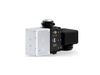
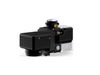
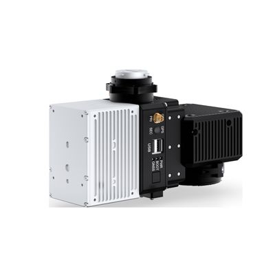
RESEPI - Model Lite AVIA -Remote Sensing Payload Instrument
RESEPI (Remote Sensing Payload Instrument) is a sensor-fusion platform designed for accuracy-focused remote sensing applications. RESEPI utilizes a high-performance Inertial Labs INS (GPS-Aided Inertial Navigation System) with a tactical-grade IMU and a high-accuracy dual-antenna CNSS receiver, integrated with a Linux-based processing core and datalogging software. The platform also provides a WiFi interface, optional imaging module and external cellular modem for RTCM corrections. RESEPI can be operated by a single hardware button or from a wirelessly connected device via a simple web interface.
RESEPI equipped with AVIA LiDAR is the lightest configuration, coming in at below 1kg. This enables longer flight times and increases the selection of drone platforms ton include those with lower payload capacity. The narrow scan field of view concentrates laser measurements resulting in a higher ground point density. RESEPI AVIA is a compact, lightweight, and competitively priced scanning and mapping solution.
RESEPI AVIA excels at surveying thin objects such as powerlines. Utility lines are long with a small diameter and can be hard for some lasers to track AVIA`s high point density causes the lines to stand out and appear more clearly in point cloud data. Another great application is surveying long distances over large tracts of land such as airport runways or racetracks. RESEPI AVIA can be flown at higher speeds and the narrow Field of View allows for preservation of point cloud density. Coupled with the lighter weight of the payload, available flight time is improved.
- System Vertical Accuracy (5m/s @ 50m): ±5cm
- Recommended ACL: 50100m
- Weight: 1.24kg (with camera) .92kg (without camera)
- Dimensions: 20x 13 x 9.2cm
- Max Flight Time (DJI M300): 35 Minutes
- External Storage: 256CB USB Included