

- Home
- Companies
- Inertial Labs, a VIAVI Solutions ...
- Products
- RESEPI - Model Lite XT-32M2X - Remote ...


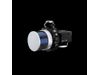
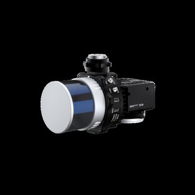
RESEPI - Model Lite XT-32M2X -Remote Sensing Payload Instrument
RESEPI (Remote Sensing Payload Instrument) is a sensor-fusion platform designed for accuracy-focused remote sensing applications. RESEPI utilizes a high-performance Inertial Labs INS (GPS-Aided Inertial Navigation System) with a tactical-grade IMU and a high-accuracy dual-antenna CNSS receiver, integrated with a Linux-based processing core and datalogging software. The platform also provides a WiFi interface, optional imaging module and external cellular modem for RTCM corrections. RESEPI can be operated by a single hardware button or from a wirelessly connected device via a simple web interface.
RESEPI XT-32M2X makes use of Hesai`s enhanced M2X LiDAR scanner which features lighter weight and extended detection over the XT-32 LiDAR. This enables an M2X equipped RESEPI to fly longer, combined with a higher recommended AGL and wider vertical FOV to more effectively map larger areas and sites with dense vegetation cover. It is all-around a very attractive system, offering the benefits of best-in-class data accuracy, better detection range, high point density, and versatility.
The RESEPI XT-32M2X was strategically designed for multiple application bases with mounting options for: mobile vehicles, DJI supported drones (DJI M300, M600 Pro), custom drones, handheld platforms, vehicles, the Freefly Alta-X, and many more. Because of this diverse mounting portfolio, the RESEPI can be used for many services including: utilities mapping (powerlines), construction volumetrics, site surveying, precision agriculture, forestry, mining operations, and much more.
- System Vertical Accuracy (5m/s @ 50m): ±3cm
- Recommended ACL: 50-100m
- Weight: 1.23kg (with camera) .87kg (without camera)
- Dimensions: 20.8x14.8x15.2 (cm)
- Max Flight Time (DJI M300): 35 Minutes
- External Storage: 256CB USB Included