

- Home
- Companies
- Spottitt Ltd.
- Products
- Route Planning and Construction ...
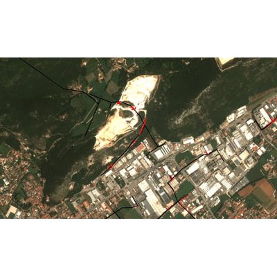
Route Planning and Construction Monitoring
Choose optimal routes for your infrastructure projects and get a holistic view of its construction, at scale. Choose optimal routes, considering terrain factor, weather conditions, and potential obstacles, Monitor progress, identify potential issues in a timely manner, all from a bird`s-eye view, Ensure your construction activities align with regulatory and safety standards
Route planning and construction monitoring present multifaceted challenges across roads and railways operators, energy grids and pipelines. Navigating complex terrains, mitigating numerous risks, ensuring environmental compliance, adhering to rigorous regulations – all contribute to the intricacy of these endeavors.
Satellite-based monitoring emerges as the optimal technology for overcoming these challenges, as it provides:
- Comprehensive Coverage: Satellites offer a broad view of vast-spread infrastructure, providing comprehensive coverage that is challenging for ground-based methods to match.
- Remote Accessibility: Satellites enable monitoring in remote or inaccessible areas, ensuring that even the most challenging terrains can be effectively observed. Unfavourable weather isn’t a hurdle.
- Cost-Effectiveness: Satellite monitoring eliminates the need for extensive equipment and personnel, reducing costs associated with traditional monitoring methods and offering more cost-effective cost per kilometer.
- Near Real-Time Data: Satellite-based monitoring provides prompt data on construction progress, environmental changes, and asset conditions, enabling timely decision-making.
- Data Accuracy: Satellite technology delivers accurate and up-to-date information on variety of conditions, supporting regulatory compliance, environmental impact assessments, and safety standards.
We provide comprehensive and frequent monitoring using remote sensing data, which allows for detailed risk analysis and its timely prevention.
- Trees
- Cropland
- Heat & scrub
- Grassland
- Buildings
- Precipitation
- Soil moisture
- Temperature
- Humidity
- Change vegetation to urban
Spottitt MF allows asset managers to get accurate geospatial analytics to track all possible risks on every meter of their assets, at scale, without breaking the budget
Satellite-based analyses to avoid any hardware installation or flight permits
We automated the full process of getting satellite data and transforming them into actionable insights
View, filter and integrate our metrics the way you need, without replacing your current management systems