Delair Marine. Formely known as Notilo Plus

SeasamNavigator ROV GPS

SHARE
The Seasam Navigator is an innovative solution designed to address the significant challenges faced by ROV (Remotely Operated Vehicle) operators in underwater navigation and asset inspection. Traditional communication methods like Wi-Fi and cellular networks fail underwater, but the Seasam Navigator overcomes this with its advanced underwater geolocation capabilities. Equipped with a long-range WiFi transmitter, the Seasam Navigator allows for low-latency, remote control of Seasam ROVs without the need for a tether, minimizing entanglement risks and enabling extended reach during inspections. It excels in complex environments like marinas and crowded docking ports, and is ideal for comprehensive ship hull inspections. The integrated GPS geolocation ensures precise data capture, which can be visualized in real-time on the Seasam Control application. The device can place geolocated markers for detailed review at any time. Additionally, the Seasam Navigator functions as a standalone Unmanned Surface Vessel (USV), powered by three thrusters for autonomous navigation and waypoint tracking. With a payload capacity of 2kg, it supports various mission types and third-party sensors. Mission data can be uploaded to Notilo Cloud for post-inspection analysis.
Most popular related searches

One of the biggest challenges of ROV operators is to navigate and orient themselves underwater to inspect their assets. The natural barrier between air and water prevents most means of standard communication, such as Wi-Fi or cellular networks, to be used with underwater assets.

Seasam Navigator is the underwater geolocation answer to this challenge.

  • Long range transmission
  • Underwater geolocation
  • Standalone USV
  • Waypoint navigation

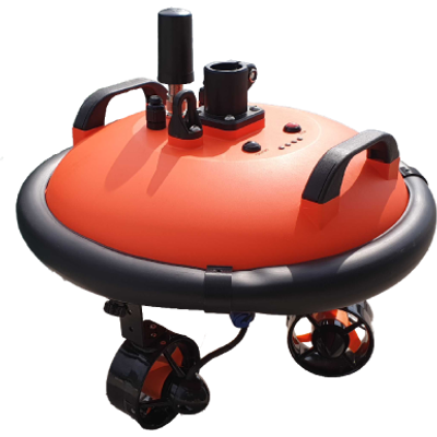
Seasam Navigator embarks a long-range WiFi transmitter, and enables a low-latency, remote control of the Seasam ROV. Wireless means there is no tethered connection between operator and ROV, which reduces risk of entanglements, and extends the reach of inspections.

This simplifies navigation in complex environments such as marinas and crowded docking ports, as well as full ship hull inspections without adding the stress of cable management.

Geolocation of data is a must have for modern data capture and analysis. With Seasam Navigator, you are able to precisely locate the position of the data you capture.

View Seasam Navigator and Seasam Drone position in the real-time on the map in Seasam Control application. Place geolocated markers at the touch of a button before and during the inspection, and review this data anytime.