

- Home
- Companies
- Landviser, LLC
- Products
- SibER - Model RES/IP - Subsurface ...
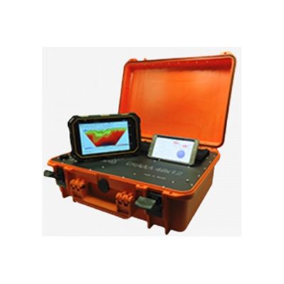
SibER - Model RES/IP -Subsurface Imaging Device
Landviser, LLC is offering advanced equipment for deep electrical tomography (RES/IP/SP) – SibER – manufactured by KB Electrometry, Ltd in Novosibirsk, Russia. Since 2012 they started to produce modificated version of “SibER” which became quickly became very popular worldwide. New device has safer body, powerfull generator (inject current up to 2A), provide more stable and faster measurments.
All resistivity methods in geophysics are based on applying a known DC through a couple of output electrodes set on the ground surface and measuring the voltage caused by this current through another couple of electrodes, as in the well-known four-electrode measurement method, also implemented in our handheld LandMapper device.
With the known current and voltage, we can calculate the resistance; and for a known configuration of the electrode array, through geometrical coefficients, we can establish the true resistivity of the ground layers without digging. The larger distance between current electrodes corresponds to a higher depth of resistivity survey and this is the main sounding factor for Vertical Electrical Sounding (VES) technique.
However, an operator of SibER can get realization not only for the VES method but also for the method of Dipole Electrosounding (DES) and for constant separation traverse (CST) when the separation between electrodes remains constant but the entire setup is reallocated within the profile or the site.
- Mapping underground utilities.
- Monitoring of the state of underground utilities;
- Determining the location of underground utilities, structures, etc.;
- Search for the source of the leak and estimate the amount of leakage from the pipelines.
- Localization of archaeological sites;
- Localization and analysis of archaeological objects – burials, artifacts, household items;
- Mapping of ancient structures to determine the locations of foundations and walls of destroyed buildings;
- Monitoring of the state of the architectural monuments hidden under the ground.
The survey of the building basis allows you to get the necessary data on the exploitation of structures, their reconstruction, the construction of additional superstructures over them.
Such operations are especially necessary with the expected increase in dynamic loads on the ground in the following cases:
- increasing the number of floors;
- placement of heavy equipment inside building structures;
- there is a necessity to strengthen the structure.
Use electrical tomography with SibER system to obtain the most accurate data about the layers of soils and their physical and mechanical properties.
It will help you:
- to select the required materials for construction;
- to increase the safety of building exploitation.
- Underground water search;
- Distinguish between salt and fresh water;
- Ground exploration for placement of water wells.