

- Home
- Companies
- CoRHIZE sarl
- Products
- Soil Mapping
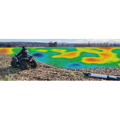
Soil Mapping
Soil mapping over several horizons is the first link in Precision Agriculture. It offers very important and multiple levers for agronomic progress .
- CEREALS
- POTATOES
- SEEDS
- VINEYARDS
- ORCHARDS
- VEGETABLES
To map the soil, CoRHIZE uses technology based on electrical conductivity. To make simple, conductivity is the soil capability to conduct an electric pulse througt . And the higher the conductivity, the higher the clay-humic complex. The electrical conductivity is used as an indicator of the intrafield variability of the soil. It is a very reliable parameter that can be used on all types of soil. Soil mapping is a long-lasting and profitable investment.
Above all, soil mapping provides a better understanding of the agronomic potential of its plots. By bringing them together with historical observations in the field, it allows to ask good questions and generally provide the right answers.
TO KNOW: if vegetation maps are carried out by satellites or drones, soil maps over several depths can ONLY be carried out by specific measurement tools dragged on the ground.