
Soil Vapour Surveys/Methane Gas
Soil Vapour Surveys are an integral tool for the location of contamination “hotspots”. They are used as an aid in determining the nature and extent of contamination at a site. The soil vapour survey confirms the presence of vapours in the subsurface environment and can serve as a guide in decided upon locations for intrusive investigations.
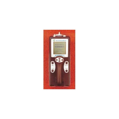
The detection of organic contaminants such as Light Non-Aqueous Phase Liquids (LNAPL) and Dense Non-Aqueous Phase Liquids (DNAPL) in the sub-surface is an integral part of site investigations on contaminated land. NAPL contamination may differentiate into at least four distinct bodies, each of which has unique chemical and geophysical characteristics. Firstly there is free product, which is mobile or free to migrate under the influence of gravity. Secondly, the residual phase is the portion which is left behind after the free product has migrated. Thirdly, volatile NAPLs have develop a vapour phase plume in the region above free product and residual product. Finally, small amounts of hydrocarbon enter the aquifer as a dissolved phase. Surveys are undertaken using the RS Dynamics Ecoprobe which is based on the most advanced technology, providing flexibility, convenience and quality for the in-situ detection and analysis of VOC’s. The instrument incorporates a combination of a PID (photoionisation detector) for the measurement of volatile organic compounds and a selective Infra Red analyser for the separate measurement of Methane, Non-methane hydrocarbons and Carbon Dioxide). These parameters are further complemented by temperature, pressure and oxygen measurement. Data are collected from either a pre-determined grid or via an integrated dGPS Sampling can be undertaken directly at the surface or via hand augured holes to depths of up to 1.5m bgl. This level of flexibility means that data can be recorded at the site at increasing depth intervals to provide detailed 3D information on the soil vapours at the site. The data are presented onto detailed colour coded contour maps which can then be used to determine areas requiring intrusive investigations in the form of borehole installation and trial pits. As a further service gas samples can be collected into Gresham Tubes and taken directly to a laboratory for thorough analysis of a number of determinands. In areas of particularly high identified contamination soil gas spikes are driven into the ground and samples are transferred into the tubes and couriered directly to a suitable laboratory.
- Landfill surface emissions monitoring, and leak detection testing.
- Locating and identifying buried mine workings.
- Monitoring pipe lines for leakage.
- Waste dumps and agricultural waste measurement.
- Monitoring of in-situ bio-remediation processes.
- Monitoring of contaminant plume migration
- Detection and monitoring of methane effluence over closed mines.
- Detection and delineation of organic contamination from contaminated sites.
- Air pollution monitoring.