

- Home
- Companies
- SyQwest Incorporated
- Products
- SyQwest - Model Bathy-500 HD - HD ...
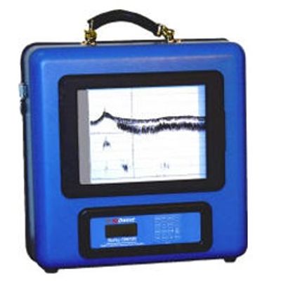
SyQwest - Model Bathy-500 HD -HD Survey Echosounder
Bathy-500 HD can also be ordered with an optional DGPS receiver built in.
- Compatible with industry standard hydrographic post processing software
- Thermal Recorder
- Depth Resolution 1cm
- LCD Display; RS232/422 Output
- External Programmable Annotation
- GPS/NAV Integration;
- NMEA 0183 Input
- Frequencies of Operation - 33, 50, 200kHz, (seleced at time of order)
- Power 11-30VDC, 115/230V, 50/60Hz, < 40watts
- Windows 7/8/10 Compatible
Depth Ranges(frequency dependant): Units of 0-15, 0-30, 0-120, 0-240, 0-450, 0-900, 0-1500, 0-2400, 0-3000 Feet or 0-5, 0-10, 0-20, 0-40, 0-80, 0-150, 0-300, 0-500, 0-800, 0-1000 Meters. Auto ranging modes in all units.
Phasing: 0-120, 60-80, 120-240, 180-300, etc.. (displays 120ft range at 60 ft increments up to 1800-1920) Feet, Auto; or 0-40, 20-60, 40-80, 60-100, 80-120, etc.. (displays 40m range at 20m increments up to 600-640) Meters, Auto
Chart Record: 8.5 inch X 90 Feet High-Contrast Thermal Paper
Digital Display:
- LCD (4 lines x 16 characters) 0.25 inch characters
- (Depth Display: 0.75 inch characters)
- (Back-lighting: Electro-luminescent)
Resolution:
- 0.01 units for depths less than 100 meters;
- 0.1 for depths greater than 100 meters;
- 0.1 feet on all ranges
Accuracy:
- Meets or exceeds all current IHO hydrographic requirements for single beam echo sounders.
- At 33 Khz= 5 cm +/- 0.1% of depth
- At 210Khz= 1cm +/- 0.1% of depth
Frequency:
- Any single frequency (user selectable at time of order) from these:
- 33 Khz, 50Khz, 210Khz (Acousitc output=600 watts)
Depth Alarms: Shallow and Deep (selected by keypad)
Sound Velocity: 4600-5250 feet/second (1393-1590 meters/second) (user selected via keypad)
Offset: 0 to +30 feet or meters (allows the user, via keypad, to adjust for the net sum of transducer depth and tide)
Geographic position: NMEA-0183 GGA or GLL Format from GPS/DGPS
Data I/O compatibility:
- COM 1 provides bi-directional interface to PC or other peripheral device; This port accepts external annotation from external sources such as hydrographic software.
- COM 2 accepts GPS/DGPS inputs and provides additional (from COM1) data outputs.
Data Outputs:
- ODEC PMC dt (True Depth & Status)
- Atlas DESO-25
- Odom Digitrace
- Odom Echotrac
- NMEA DBT
- NMEA DBS
Input Power: 11-30 volts d.c. (1.5 amps @ 12v. 0.5 amp @30v.)
Dimensions:
- Height (including handle) 19 inches
- Width 17.5 inches
- Depth 9 inches
Weight: 35 lbs. (Recorder with P01540 Transducer)