
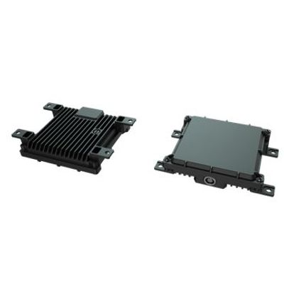
. Up to 1,640 ft range measurementBuilt solid for tough environments
- Ruggedized design meeting IP67 requirements
- Smooth, consistent readout regardless the rough terrain, tree canopy or choppy water.Highly Accurate
Advanced cross-validation technology continuously monitors multiple data sets for higher accuracy.
Ainstein’s UAV Long Range Radar Altimeter LR-D1 provides accurate altitude measurement in these diverse operating environments, giving you the confidence you need to fly by knowing exactly how much space you have to maneuver — especially during landing.
The Ainstein UAV Long Range Radar Altimeter LR-D1 provides advanced cross-validation technology that continuously monitors incoming data, assuring the measured altitude is accurate, even in low-visibility conditions.
LR-D1 also measures vertical speed of your plane, giving you added data points for safe take-off and landing.
It’s perfect for experimental helicopters and pilots under training for use in safe takeoff and landing; it’s also a must-have for advanced UAVs in automatic takeoff and landing.
Fairweather IT (FIT), was using LiDAR to fly over dangerous waters. Although it worked great over land, water was a different story. The water FIT monitors have such a high level of toxicity that any collision is a 100% loss of the UAV. Ian found Ainstein and now uses the US-D1. As Ian puts it, the US-D1 “works flawlessly” over all the many terrains his organization encounters.
HIGH PRECISION CROP MONITORING DRONE SOLUTIONWith Ainstein’s acclaimed drone radar altimeter, our crop monitoring drone solution is designed for rough terrain! It is the only market-ready solution that maintains a constant above-crop canopy elevation, ensuring more accurate and precise readings of your fields with MicaSense RedEdge-M Sensor.
- Improve efficiency of fertilizer application
- Provide early disease detection
- Facilitate more precise irrigation practice
- Enable targeted pesticide, fungicide and herbicide applications
- Reduce driving of your field