

- Home
- Companies
- Veris Technologies, Inc.
- Products
- Veris CoreScan - Automated Soil Sensor ...
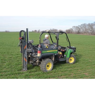
Veris CoreScan - Automated Soil Sensor Probe
CoreScan is the only automated soil sensor probe delivering real-time, high-resolution data on key soil properties like compaction, moisture, organic matter, and texture. Designed for fast, automated field use, CoreScan captures detailed soil profiles at sub inch intervals down to 2 feet (or 3 ft in manual mode), enabling farmers and agronomists to see what`s happening below the surface.
The CoreScan™ covers 50ac/hr with proven sensor technology on a wide range of vehicle platforms for ultimate deployability and versatility. In real-time visualize the rooting profile using SoilViewer in-cab software.
A groundbreaking tool that digitally captures multi-layered soil properties with precision. Offering rapid, in-depth soil analysis, it enables advanced agricultural practices and effective nutrient management, while providing essential data for carbon sequestration and soil health baselines. Perfect for informed, precise farming decisions.
Sensor Technology:
Compaction: Force sensors measure penetration resistance providing data essential for understanding soil compaction levels which affect root growth and nutrient uptake.
Soil Carbon/Organic Matter: A dual-wavelength Visible-Near Infrared (Vis-NIR) optical sensor is used for measuring soil organic matter and carbon content, crucial for assessing soil health and carbon sequestration. Used for measuring soil organic matter and carbon content, crucial for assessing soil health and carbon sequestration.
Soil Texture/ Nutrient and Water Holding Capacity: A Bulk Apparent Electrical Conductivity (ECa) sensor measures the ability of soils to conduct electricity which is primarily driven by particle size and determines water-holding capacity and CEC.
Moisture: a capacitance sensor measures the dielectric permittivity of the soil-- the ability of the soil to store electrical energy. This measurement can then be converted to soil water content for understanding water dynamics within the soil.
Sensor Fusion: Through Machine Learning and Pedotransfer Functions, the multiple sensor datasets can be used in predicting bulk density, natural soil nutrient variation patterns, and more.
Depth Range: The CoreScan can analyze soil profiles from the surface down to one meter / three feet deep in manual mode and up to 60 cm / two feet in automated mode.
Data Resolution: Provides high-resolution data with measurements taken at 1 cm intervals, offering detailed insights into soil structure and variability.
Operational Efficiency:Insertion Time: A single insertion takes between 8-10 seconds.
Coverage Speed: Capable of covering up to 50 acres per hour (at a 1 acre density), making it efficient for large-scale farming operations.
Soil Coring Capabilities: A soil coring hardware is included for taking validation and visualization physical cores
In-Crop Sensing: because the CoreScan™ is only engaged in the soil at the sampling locations, it is possible to map during the growing season.
Mounting Options: Flexible mounting capabilities include setups for UTVs, trucks, tractors, and an option for handheld use, accommodating various farm sizes and operational preferences.
Data Integration and Usability:Data Visualization: Results are visible in real-time during sensor insertion. Multiple insertions can be reviewed and compared side by side.
Data Processing: Veris provides a quality control and lab calibration service using the FieldFusion™ platform.
Data Compatibility: the processed data results are provided in a flexible and adaptable form that can be integrated into third party software, helping users interpret and utilize soil data effectively.
Training and Support: Veris Technologies offers comprehensive training sessions and ongoing support to ensure users can maximize the tool`s capabilities and integrate its insights into their farming practices effectively.
Variable Rate Seeding
Tailor your seeding strategies with confidence. The Veris U3`s precise soil maps support variable rate seeding, ensuring optimal seed placement based on soil characteristics, enhancing germination rates, and ultimately, crop uniformity and yield.
Environmental Research and Conservation
Contribute to environmental research by mapping and analyzing soil conditions over large areas quickly. The U3`s rapid scanning capability is ideal for conservation projects aiming to assess and manage soil variability and its impact on ecosystem services.
Soil Health Monitoring
Continuously track and improve soil health. The U3 offers in-depth analysis, identifying areas that require attention—be it pH adjustment or organic matter enhancement—allowing for targeted interventions that boost soil productivity and sustainability.
Precision Agriculture
Maximize your farm`s potential with the Veris U3. By providing detailed soil pH, organic matter, and texture data, it enables the creation of precise management zones, optimizing fertilizer application and crop yields across variable soil conditions.
Variable Rate Seeding
Tailor your seeding strategies with confidence. The Veris U3`s precise soil maps support variable rate seeding, ensuring optimal seed placement based on soil characteristics, enhancing germination rates, and ultimately, crop uniformity and yield.