

Vantage Agrometius BV
- Home
- Companies
- Vantage Agrometius BV
- Products
- Veris - Model MSP3 - Soil Scanner
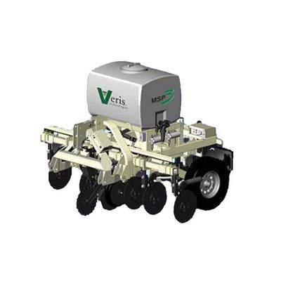
Veris - Model MSP3 -Soil Scanner
The Veris MSP3 soil scanner is a unique sensor platform by means of which, in one operation, 4 important soil variables and the altitude are charted. The Veris soil scanner is built up of 3 sensor systems which can also be supplied separately. While driving at about 8 to 15 km/hour, the system measures the acidity (pH), the organic matter percentage and the EC at growing depth (0-30cm) and in the root zone (0-90cm). Scientific research, carried out by PPO (Applied Plant Research) Lelystad, has shown that the maps by the Veris MSP3 are very reliable.
Most popular related searches
soil scanner
tapered roller bearing
roller bearing
scientific research
sensor system
mapping software
plant science
organic matter monitoring
protection cap
organics monitoring
- Charting the soil, place-specific
- 5 measures by one machine
- pH, organic matter and EC measurement
- Work speed about 8 to 12 km/hour
- Very reliable data
- Important basis for precision farming
- The MSP3 measures the lutum content in the soil
General:
- Overall dimensions (WxHxL): 229 cm x 182 cm x 275 cm
- Weight: basic implement without weight package: 1800 lbs (635 kg)
- Road Kit: stop, turn, and clearance lights with 4 pin flat trailer plug
- Tire size: P205 R75 highway tires
- GPS Requirement: NMEA 0183 protocol; input from GGA and VTG or RMC strings at a 1 Hz rate (4800-8-N-1); serial connection with DB9 connector, female sockets; GPS signal on pin 2, ground on pin 5; no signal or power on other pins
EC Surveyor instrument:
- Coulter-Electrode Blade Diameter: 17” (43 cm); thickness 4mm; with tapered roller bearings and cast iron hubs
- Rock guards for hub and cap protection
- Power: 10-15 volts DC; cigarette lighter power cord included
- Input: EC signal cable
- Data recording: Veris SoilViewer on laptop PC (Windows XP or 7 OS)
OpticMapper Module
- Compatible with Windows XP or 7 OS
- Displays EC, OM, and pH data real-time for coverage verification and visual review of map quality
- Records geo-referenced soil data to computer
SoilViewer On-the-go mapping software
- Compatible with Windows XP or 7 OS
- Displays EC, OM, and pH data real-time for coverage verification and visual review of map quality
- Records geo-referenced soil data to computer