

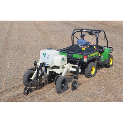
Veris - Model U3 - (UTV Series) -Soil Mapping
The Veris U3 allows rapid data collection over a wide window of soil and cropping conditions. The reduced total investment required and the high value of data contribute to advisors and their growers seeing immediate positive returns on their investment. Designed for ultimate versatility, easily mounting to a range of vehicles to deliver precise, actionable soil insights.
Soil Sensing Capabilities:
- pH Module: SpeedRead™ technology for quick pH measurement using ion-selective electrodes, providing readings in 8-10 seconds.
- Organic Matter (OM) Module: Dual-wavelength infrared soil optical sensor to assess organic matter levels below the surface.
- Electrical Conductivity (EC) Module: Measures soil texture and water-holding capacity with a disc array that measure deep into the rooting zone.
Operational Efficiency:
- Mapping Speed: Capable of covering up to 400 acres per day, optimizing time in the field.
- Vehicle Compatibility: Specifically designed for use with a UTV, truck or tractor allowing for easy integration and mobility.
- Hydraulic Requirements: onboard electrohydraulic system makes it suitable for a wide range of vehicles.
Data Management and Software:
- SoilViewer™ Software: On-the-go mapping software included, which allows real-time data viewing and logging on a PC.
- Bluetooth Connectivity: simplifies operations with fewer wires and connections.
- GPS Integration: Comes with an internal Garmin GPS for precise location tracking and mapping.
- Data Visualization: User-selectable colors, ranges, and point sizes with zoom control for customized map viewing.
Design and Build
- Sensor Protection: sensors are protected by wear parts designed for long life and easy replacement.
- Durability: Robust construction tailored for field durability and prolonged use in various soil conditions.
- Setup Simplicity: Designed for quick attachment and detachment, facilitating ease of use across different vehicles and operations.
Variable Rate Seeding
Tailor your seeding strategies with confidence. The Veris U3`s precise soil maps support variable rate seeding, ensuring optimal seed placement based on soil characteristics, enhancing germination rates, and ultimately, crop uniformity and yield.
Environmental Research and Conservation
Contribute to environmental research by mapping and analyzing soil conditions over large areas quickly. The U3`s rapid scanning capability is ideal for conservation projects aiming to assess and manage soil variability and its impact on ecosystem services.
Soil Health Monitoring
Continuously track and improve soil health. The U3 offers in-depth analysis, identifying areas that require attention—be it pH adjustment or organic matter enhancement—allowing for targeted interventions that boost soil productivity and sustainability.
Precision Agriculture
Maximize your farm`s potential with the Veris U3. By providing detailed soil pH, organic matter, and texture data, it enables the creation of precise management zones, optimizing fertilizer application and crop yields across variable soil conditions.
Variable Rate Seeding
Tailor your seeding strategies with confidence. The Veris U3`s precise soil maps support variable rate seeding, ensuring optimal seed placement based on soil characteristics, enhancing germination rates, and ultimately, crop uniformity and yield.