
General Acoustics e.K.
General-Acoustics - Model LOG_aLevel -Water Level Gauge
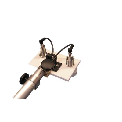
LOG_aLevel is a remote sensing, stand-alone Water Level Gauge (Tide Gauge). The system can work with ultrasound, radar or pressure sensors. It is extremely robust & reliable and is used for precise measurements of all kinds of water levels and wave dynamics (up to steep waves). The system can be easily extended to include a datalogger, data communication systems and additional hydrological and meteorological system to form a complete monitoring station. Furthermore, multiple LOG_aLevel stations can be interconnected to form a network. Integration in SCADA systems is straightforward.
Most popular related searches
water level gauge
level gauge
tide gauge
pressure sensor
remote sensing
ultrasound sensor
power data logger
early warning system
meteorology sensor
wave monitoring
- For a Mobile tide gauge please see: LOG_aLevel Mobile
- For tide gauges for Offshore Platforms please see: LOG_aLevel Long Range
- Talk to us for your need in Wave Direction Measurements. We can provide systems for inland, coastal, offshore and laboratory applications!
- Easy to install
- Cost effective
- Extremely Robust & reliable
- Calibration-Free
- Maximum Accuracy at all times
- Maintenance-Free (no moving parts, remote sensing)
- Reliable under Extreme Conditions: Flood, Ice, Storms, Debris, etc.
- Narrow Ultrasound Beam for Accurate Level even at Wavy Water Surface
- Simultaneous Wave and Level Measurement
- Extension With Additional Sensors (Redundancy, Meteorology and Hydrology)
- Remote Data Transmission, Control and Alerting
- Easy Integration to Measuring Networks
- Reduced risk of malfunction in case of flood and ice (no frozen level gauges!)
- Fast measurements (measurement of steep waves is possible)
- Remote sensing without influence to water surface
- Continuous speed of sound measurement with Reference sensor REF-300 ensures an always accurate, calibration-free system (applies to systems with ultrasound sensors)
- Housing: 300x400x200mm or 500x500x200mm stainless steel with lock, seawater resistant IP class up to 67
- Mounting of Sensors: Seawater resistant pole (stainless steel) with mounting plate
- LOG_aLevel Windows Software for system set-up, analysis of measuring network, visualization, managing, storing and exporting of data
- Measuring range: depends on sensor technology (Ultrasound, Radar, Pressure)
- Sample rates: up to 5 Hz
- Resolution: 1 mm
- Accuracy: 1 cm
- Power supply: 12 VDC ( 230/110V AC optional)
- Data output: RS232 or RS485
- Working temp: -20°C up to +70°C
- Ultrasound, Radar and Pressure Sensors (see table below for details)
- Power autonomy: Backup battery up to 200 Ah, Solar Power, Wind Power
- Data logger with SD memory card (4GB / 8GB)
- Data transmission: Radio, GPRS, Satellite, Cloud, AIS, AIS AtoN
- Integration of any desired Hydrological and Meteorological Sensors (also in data stream, visualization and logging)
- Example Hydrological sensors: Water temperature, Inductive current meter, ADCP, Surface Current Flow, CTD, Salinity, Conductivity, Dissolved Oxygen, etc.
- Example Meteorological sensors: Wind gauge, Air temperature, Humidity, Rain, Ice, Solar Radiation, Barometric Pressure, Cloud Height, Visibility, complete Weather Stations and sensors for Helidecks, etc.
- Time: High accuracy GPS – date and time (pps, 1ms accuracy)
- Data Server / Database
- Website
- Alerting / Early Warning System
- Tide Analysis and Prediction (please see TidePrediction Software)
- Hypack – Export or Data Stream
Measurement Range:
- Ultrasound Sensor : Maximum distance from Sensor to Water: 10 meters (for larger ranges please see LOG_aLevel Long Range)
- Radar Sensor : Maximum distance from Sensor to Water: 10 meters (for larger ranges please see LOG_aLevel Long Range)
- Pressure Sensor: : Maximum depth: 50 meters
- Water level and tide monitoring
- Coastal protection
- Harbor and Terminal Management
- Storm Tide, Flood and Tsunami Measuring Networks
- Hydrology and Environmental Monitoring
- (Temporary) Level Gauge to Support Dredging, Surveying and Construction Works
- Spectral Wave Energy Analysis for Optimal Survey Quality
- Water/Fluids Reservoir Management
- Wave Monitoring and Analysis
- Ship Induced Waves
- Load Determination for Hydraulic Engineering
- Torrent Monitoring
- Local Event Alerting e.g. Flood, Tsunami
- Real-Time Data for Vessels through AIS/AtoN
- Local Tide Analysis and Prediction System together with Tidepredictor Software
- Wave Measurements from Jack-Ups and Rigs
- Server-based Fleet Management Networks incl. Web Portal (e.g.Ferries, Water-Planes, Supply Vessels)
- Discharge Hydrographs
- Flood warning