- Home
- Companies
- WTS Geophysical Solutions
- Products
- WTS - Model ADMT Series - High ...
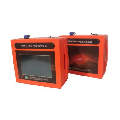
WTS - Model ADMT Series -High Precision Water Detector
ADMT series (Water Detectors) is a new age intelligent prospecting instrument designed for shallow, medium-deep, and deep GroundWater Exploration. It is entirely supported by Mobile Application software for Data Acquisition, processing, and Interpretation that surpasses the limitations of resistivity meters in Ground Water exploration. It uses a mobile phone or tablet PC to execute the complicated information calculated to realize and draw 2D/3D profile maps and contour maps by an application. This innovative advanced technology enables the detailed geophysical survey to become more accessible and simpler.
With the application, you could use many intelligent functions such as field measurement control, instant data process, cloud backup, online expert analysis, bluetooth data transaction, etc. The instrument is connected to the application through the built-in Bluetooth, so you can use the APP to realize all the instrument`s operations, such as measurement signal input, data checking, and processing. Wireless sensors can complete all the measurements by walking and stopping, with no need for ground electrodes. No need for long cable, Saving time and workforce.
- Shallow and Deep Ground Water Prospecting
- Hot Springs identification
- Portability: It is light weight, easily portable, intelligent and ease in field survey.
- System Design: ADMT device is available in two different variants ; viz Mobile App Device & Touch Screen Device.
- Depth variants :It is available in different configuration (corresponding to depth of GW Investigation) .Depth variants include 100m, 200m, 300m, 400m, 600m and 800m and above.
- Simple Operation: Unlike Resistivity survey, which require large space for conducting VES sounding, especially for deeper investigation. ADMT Survey requires very limited space for acquiring deeper depth. Hence it effectively solves GW problem in urban area and area with space constraints.
- Instant Graphs: Directly drawing the 2D/3D map by the APP after data collection. It has wide application in Hydrogeology to find detailed information such as the direction, depth and output of ground water, greatly improving the success rate of well drilling.
- Efficiency: unique wireless prospecting technology, one person can complete all work, saving time and manpower.
- Precision: Strong anti-interference ability, field source correction and patent tech to process data.
- Online Expert analysis: Online professional expert to help analyze to determine the best drilling location.
- Data Protection: Data cloud storage, no need to worry about the data.
- Lifetime Validity: Lifetime free upgrade of Mobile app, ensures that device is always up to date , consistent , operating correctly. It reduces the risk of downtime to absolute minimum and enhances survey results to absolute maximum.
- Sensor: High-precision electromagnetic sensor is optimized for special anti-noise processing to match the appropriate measurement accuracy. Sensor enables survey in rocky surface, roads, cemented platform with accuracy and success.