
ZOGLAB Microsystem Co., Ltd
- Home
- Companies
- ZOGLAB Microsystem Co., Ltd
- Products
- ZOGLAB - Model UAV6000 - Meteorological ...
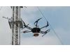
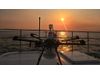
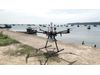
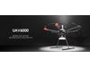
ZOGLAB - Model UAV6000 -Meteorological detection UAV
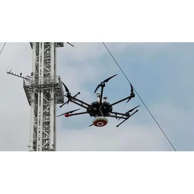
UAV6000 is a compact medium-low altitude meteorological detection UAV(Unmanned Aerial Vehicle), with measurement of temperature, humidity, air pressure, wind speed, wind direction and other parameters. With the design concept of modular, solid and digital sensor, you can quickly monitor the air quality and environmental information, and improve the access to information on the speed and accuracy. The application of mature UAV is to build flight control platform with replaceable pod design, according to the different detection needs of the sensor type or camera platform. In the data analysis platform, horizontal and vertical data distribution diagram will be presented according to the GPS and terrain, and calculate and display the atmospheric 3D state.Most popular related searches
unmanned aerial vehicle
meteorology instrument
environmental information
air quality monitoring
meteorology monitoring
air quality data
building control
wind monitoring
air monitoring
measurement wind direction
- Visibility measuring range 5m~50km
- Output content transmittance, visibility value
- Output format ASCII plain text display, compatible with Vaisala protocol
- Communication ports RS485
- Resolution 0.1m
- Output rate 1.000/s
- Average method 1min moving average
- Modulation frequency 1KHz
- Working environment 10~40℃ , 10%~95%RH
- Storage environment -20℃~70℃ , 10%~95%RH
- Accuracy (RVR range) Surplus the International Civil Aviation Organization (Annex 3) recommended specifications
- Humidity measuring range 0~100%RH
- Humidity measuring accuracy ±3%RH(10%RH~90%RH),±5%RH(90%RH~100%RH)
- Humidity resolution 0.1%RH
- Pressure measuring range 500hPa~1100hPa
- Pressure measuring accuracy ±0.3hPa(0℃~50℃),±0.5hPa(-30℃~0℃)
- Pressure resolution 0.1hPa
- Wind speed measuring range 0~50 m/s
- Wind speed measuring accuracy ±0.5m/s(0~15m/s)
- Wind speed resolution 0.1 m/s
- Wind direction measuring range 0°~360°
- Wind direction measuring accuracy ±2°(Deviation≤±10°), ±4°(deviation>±10°)
- Wind direction resolution 1°
- Communication ports BT,Wi-Fi*
- Max ascent speed 5m/s
- Max descent speed 8m/s
- Flying height 500m
- Hover time No payload>30min; Max takeoff weight>15min
- Working environment -30℃~50℃,10%~80%RH
- Dimensions 1668 × 1518 × 727 mm
- Flying weight 15.5kg
- Certificates CE、FCC、VCCI、C-TICK