

- Home
- Companies
- Geosoft Global
- Services
- Geosoft - 3D Laser Scanning and ...
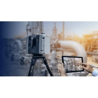
Geosoft - 3D Laser Scanning and Modeling Services
Geosoft provides the best-in-class 3D laser scanning services. Our ground-based or air-borne 3D laser scanning provides high accuracy to all projects that require field measurements. The advanced 3D laser scanners acquire and record the spatial locations of points rapidly and abundantly. We provide you with the best 3D laser scanning services by coordinating data of target profile surface to create a three-dimensional image model of structural and piping configuration for both - offshore as well as onshore.
99%
Clash free design
30%
Reduction in
engineering time and cost
15%
Reduction in
construction time and cost
80%
Reduction in hot works related to field welds and onsite modifications
Tie-in
Point Verification
We provide virtual tie-in implementation in close coordination with project team and fabrication workshop so as to achieve seamless completion of joints at site.
Pre-Engineering
Site Survey
We provide accurate pre-engineering site survey data in digital form. Compatibility of data with standard engineering software makes designers’ job easier and faster.
3D Modeling
and 2D Drawing Extraction
Geosofts’s specification and catalogue driven 3D intelligent models developed from point cloud ready for 2D Drawing extractions.
Plant
Visualisation
We provide laser scanned plant models that are virtually built with high accuracy and strict dimensional controls for better visualization of scope of work and planning.
Virtual
Constructability
Geosoft's 3D Laser Scanning and Modeling services help virtual constructability of clients’ process development needs with unlimited design review options. This promotes operational innovation with agility and cost effectiveness.
Design
Clash Analysis
Once desired modification is finalized for implementation, we help clients to validate their design for structural compatibility with existing piping structure for clash free job.
Fabrication
Verification Survey
We provide 2D fabrication drawings based on 3D model. We carry out workshop fabrication verification survey before delivery of structure and spools at site.
Dimension
Control
With abundant dimensional coordinates data obtained during laser scan, we achieve accurate dimensional control during preparation of 2D fabrication drawings and workshop fabrication of spools.