
Fire & Gas Detector Mapping Services
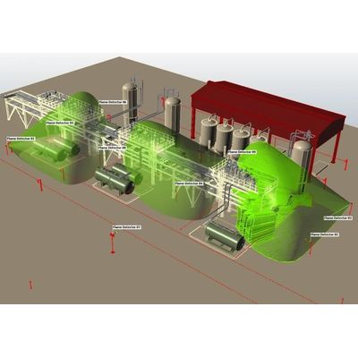
FGDS computer modelling of Fire & Gas Detector selection, and placement, can optimise the number and position of detectors to increase plant safety, and provide enhanced detection coverage both Onshore and Offshore Installations. We can provide detailed indications of potential gas dispersion and movements over time from identified leakage points. The mapping study commences by assessing the risk and definition of the “detection target”, gas leak points are identified, and dispersion patterns plotted, fire zones are detailed and then the detector type and quantity evaluated to ensure suitable detector coverage throughout the area under review.
Using the most accurate Fire & Gas Mapping software, for the design and assessment of detector layouts, flame detectors and point and open-path gas detectors can be interactively positioned and oriented within any geometry. The deliverables from 3-D Fire & Gas mapping include drawings in AutoCAD (DWG), PDF and JPEG files and a detailed report.
The deliverables from 3-D Fire & Gas mapping include drawings in AutoCAD (DWG), PDF and JPEG files and a detailed report.