Lennon, Smith, Souleret Engineering Inc.
- Home
- Companies
- Lennon, Smith, Souleret Engineering ...
- Services
- Geographic Information Systems (GIS) ...
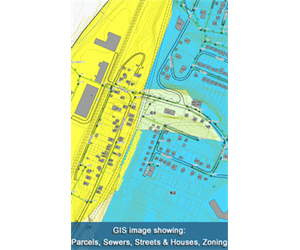
Geographic Information Systems (GIS) Services
Lennon, Smith, Souleret Engineering, Inc. (LSSE) provides GIS services in support of municipal facilities planning, capital improvement and maintenance programs on projects located throughout the Tri-state region.Most popular related searches
geographic information system
GIS service
geographic information
infrastructure mapping
infrastructure management
sewage infrastructure
utility mapping
land use
sanitary sewer
flow reduction
LSSE`s recent project experience includes:
- Sewage infrastructure mapping / development of GIS landbase and infrastructure inventory database for various municipalities in Allegheny County, Pennsylvania
LSSE`s Geographic Information Systems (GIS) staff includes Civil Engineers and Environmental Technicians who are committed to providing cost-effective GIS-infrastructure management services. LSSE applies GIS technology in managing municipal infrastructure and operations.
GIS Services include:
- GIS Planning
- Map / record conversion
- Mapping / data capture
- Customized system implementation and integration
GIS Applications include:
- Infrastructure and utilities mapping, inventory, assessment and asset management
- Property inventory, assessment, permitting and code enforcement
- Land use / zoning studies and management
- Sanitary Sewer Evaluation Studies (SSES), Corrective Action Plans (CAP), I/I source flow reduction and flow monitoring
- Hydraulic characterization studies / modeling
- Operations and maintenance / CMOM regulations
- NPDES Phase II stormwater regulations
Client Satisfaction
GIS services are provided with projects to achieve practical solutions. Our project success has been measured by the rating clients give on our performance reviews, referrals and repeat business.