- Home
- Companies
- ETS (Worldwide) Ltd
- Services
- Marine Services
Marine Services
Coastal seas are a dynamic & challenging environment. Characterization of coastal waters in terms of water circulation patterns, patterns of suspended particulate matter and bathymetric evolution is important to a wide variety of engineering and environmental concerns such as coastal defence, harbour design, pollution dispersal and impact assessment.
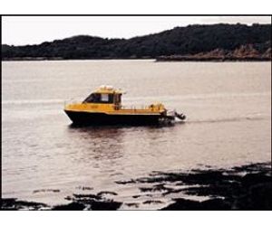
ETS possesses an extensive marine survey capability for both coastal and inshore waters, combining experienced specialist surveyors and state-of-the-art technology. ETS have undertaken numerous marine surveys for a wide range of clients including British Port and Water Authorities, regional Environment Agency offices, Municipal Councils, Marinas and Dredging Operators.
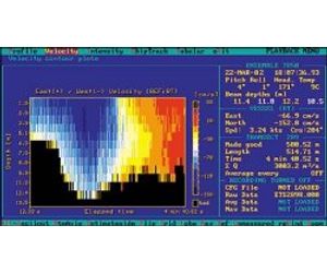
ETS offer an integrated marine survey capability and are able to characterize fully the wave and current climate, together with the dominant sediment transport pathways. State-of-the-art instrumentation including vessel / bottom mounted ADCP`s and suspended current meters are routinely used. Purpose-designed sediment traps combining commercial optical backscatter sensors are used to measure the advective suspended sediment transport. Corers and grabs are used to retrieve samples of the seabed from both cohesive and non-cohesive environments.
Hydrographic surveys may be combined with our unique Sediment Particle Tracing Technology (SPT) to confirm sediment transport pathways. SPT is now recognized in both the UK and overseas as a valuable tool in hydrographic survey to visualize inferred transport pathways of both sediment and water. To this end, SPT offers a unique method to calibrate mathematical models.
ETS offer a complete survey consultancy from initial project design to field data collection and final report completion. Services include: -
- Current velocity profiling including ADCP surveys and suspended current meters.
- Suspended sediment flux monitoring using optical backscatter sensors and sediment traps.
- Tide gauge and Met Station installation and monitoring.
- Bathymetric Survey (Side-scan Sonar).
- Surface current mapping (drogue tracking).
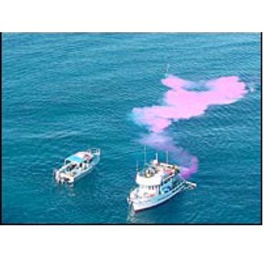
- Diffuse & point source pollution identification and monitoring
- Initial discharge dilution characteristics.
- Contaminant pathway monitoring in marine and freshwater environments.
- Hydrodynamic model calibration and validation studies.
- Seabed sampling using corers and grabs.
- In-situ particle size distribution & volume concentration (LISST instrument).
- Sediment pathway determination for dredge discharge monitoring.
- Dredge-spoil monitoring surveys, both inshore and offshore.
- Particulate dispersion monitoring.
- Initial discharge dilution modelling using CORMIX & ELSID.