

Land IQ - Remote Sensing Services
Land IQ leverages a full range of satellite and airborne remote sensing data with our understanding of agricultural and natural systems to meet our clients’ needs. Our advanced data analytics and mapping are developed to inform decision making for private industry, local and state governments, commodity organizations, water districts, and regulatory agencies. Because Land IQ’s approach is comprehensive and highly accurate, we are able to analyze a complete land surface rather than relying on surveys or extrapolation.
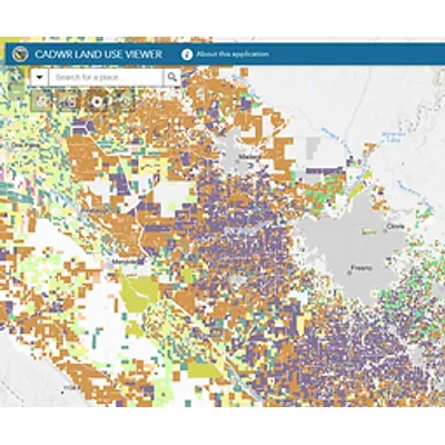
Statewide Land Use
Land IQ partnered with the California Department of Water Resources to classify more than 14 million acres, including agricultural, urban and managed wetlands with an overall accuracy of 96.6%. Land use mapping is publicly available for 2014, 2016, and 2018. The first two years contain main season (summer) cropping, while beginning in 2018, the mapping includes multi-cropping, capturing up to four cropping systems on a field over the water year. Click here to download and view the data.
Field Level Consumptive Use Determinations
Land IQ ET is a data driven model that was developed for detailed, field-scale water use estimation. Water use estimation is calculated as evapotranspiration (ET), or the amount of water consumed by the plant through evaporation and transpiration. The model uses robust ground station data and direct image analysis to interpret image data. Click here to learn more about Land IQ ET.
Urban Landscape Area Measurement (LAM)
Land IQ has assisted a number of urban water providers in understanding the impacts of the Department of Water Resources' (DWR) Urban Landscape Area Measurement and any downstream impacts on water budgets as it relates to statewide water conservation efforts.