GISonLine
Underground Detection Services
FromGISonLine
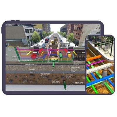
GISonLine provides comprehensive underground detection services to clients looking for detailed utility surveys, mapping products, 3D models, and Augmented Reality visualization of underground infrastructure.
Most popular related searches
ground penetrating radar
underground infrastructure
electromagnetic locating
magnetic locator
underground utility infrastructure
underground utility
underground locating
utility mapping
utility infrastructure
conductivity survey
Digital Representation of Underground Assets
- Underground infrastructure detection is a surveying process that uses specialized equipment such as Ground Penetrating Radar (GPR) and Electro-Magnetic Locators (EML) to create a digital representation of what is buried underground.
Precise Location Mapping
- Providing precise survey data and detailed mapping on the location, depth and characteristics of underground utilities & infrastructure is vital when planning & undertaking design and construction work. It also requires experienced personnel and specialized equipment to provide a comprehensive understanding and model of the infrastructure below the ground.
Trusted leader in Underground Detection
- GISonLme is a trusted industry leader in underground infrastructure detection with a wide range of experience conducting sub-surface surveys. Whether you are a developer, landscaper, builder or completing road projects & upgrades, GISonLine`s experienced te. of survey specialists can offer support and advice in support of your project.