Vessel Detection Service
The historical shelter of the high seas is increasingly less accommodating for activities such as unauthorized fishing, piracy, and smuggling as the vast expanses and remote locations which have traditionally been impossible to monitor fall under the surveillance of satellites.
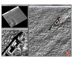
Day or night, fair weather or foul, satellite imagery makes it possible to cover large areas in near-real-time. Our vessel detection service typically begins with low-resolution radar coverage of a large area, where an initial automated algorithm continually combs data for signals of interest. Identified candidates are then manually analyzed by KSAT operators, whose experience with several thousands of satellite images minimizes both false targets and processing time.
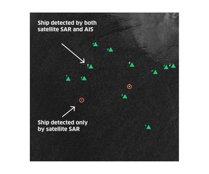
When vessel detection is confirmed the information can be acted upon in a variety of ways. For example, it can be used in combination with other tracking systems to highlight non-reporting vessels, to optimize the targeting and use of surveillance aircraft and coastguard vessels, or to initiate further identification through high-resolution optical imagery.
KSAT ground stations receive data from more satellites than any other commercial provider, providing a broad combination of high and low-resolution optical imagery and radar data. This multi-mission capability across satellites allows users to select the right tool for the job – finding an appropriate balance between coverage area and resolution and minimizing the delay between orbits by pulling data from several options.
From routine surveillance of ship traffic and coastal zone monitoring to emergency response and expanded policing, KSAT’s vessel detection services can help build a more complete maritime picture of everything from the densest ports to the most remote regions.