

- Home
- Companies
- Abyssal S.A.
- Software
- Abyssal Cloud - Subsea Data ...
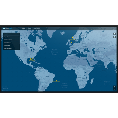
Abyssal Cloud - Subsea Data Visualization Platform
Abyssal Cloud is a comprehensive web portal designed to provide a robust solution for visualizing connected data throughout the lifecycle of subsea fields. Featuring an advanced 3D digital field view, Abyssal Cloud offers precise GIS positioning alongside contextualized data of subsea environments. Its platform allows for seamless integration of project data from various sources like Esri, SAP, and PI, thus enhancing its flexibility and utility. Professionals can instantly access, manage, and share videos and project data, with the added ability to connect to any operational platform. Its features are tailored to optimize field design, manage geographical projects, and maintain a video library for ongoing reference. Abyssal Cloud also focuses on reducing operational risks through effective project and portfolio management, empowering users with a live operational visualization tool that supports global project data management. Embracing cutting-edge technology, Abyssal Cloud is a pivotal tool for professionals in the offshore and subsea sectors.
Design. Plan. Monitor.
Abyssal Cloud provides an enhanced 3D Digital Field view, with accurate GIS positioning and Contextualized Data of the entire subsea environment. Instantly access all your videos and projects controlling how your data is used and shared.
It can incorporate project data extracted from any source (Esri, SAP, PI, etc), and can be connected to any other operational platform.
- Geographical Project Management
2D GIS application to visualize all your world-wide projects, with contextualized data.
Providing for full project transparency. - Project Portfolio Management
Worldwide project data in a single visualization platform – Abyssal Cloud – that can be linked to other platforms for KPI information. - Video Library
Comprehensive database that can be used to store offshore videos with data correlation.
It allows users to select, visualize and play videos with or without audio.
The navigation between the videos and their organization can be custom made based on client’s needs. - 3D Viewer & Field Editor
Allows engineers and surveyors to add GIS-based contextualized data, such as routes, procedures, HAZID zones, identify risk areas, adjust pipelines, take precise measurements, etc.
An enhanced view of the subsea field that allows digital collaboration.