

- Home
- Companies
- YellowScan
- Software
- YellowScan - Version CloudStation - ...
YellowScan - Version CloudStation -Advanced LiDAR Processing Software
CloudStation by YellowScan is an advanced LiDAR processing software designed to transform physical projects into digital realities with ease and precision. It streamlines the process of generating and visualizing point clouds by offering auto-detection of strips, extensive configuration options, and exports in LAS format, ensuring compatibility with various tools. The software is available as a floating license, providing flexibility to install it on multiple computers. CloudStation provides essential functionalities such as georeferencing YellowScan data, managing timestamped strips, and integrating with POSPac and Qinertia for seamless SBET generation. It supports multi-flight processing, iterative water classification, and outlier removal, ensuring quality refinement of point cloud data. An asset for survey professionals, CloudStation consistently evolves with new releases every three weeks, powered by YellowScan’s dedicated R&D team. It's built for desktop use and supports significant productivity enhancements in LiDAR data handling and exportation.
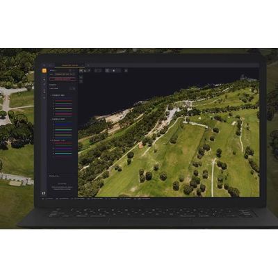
The CloudStation is an evolutive and user-friendly LiDAR software, developed by YellowScan, to generate and visualize pointclouds. Our software provides you with auto-detection of strips, in-depth configuration and LAS files exports to interface with all your tools.
Point cloud visualization, inspection, and in-depth examination
The CloudStation’s powerful 3D engine allows you to effortlessly display billions of points, measure distances, and get information about your points in one click.
*Our CloudStation software is designed for desktop use and is not cloud-based.
Increased productivity. Maximized budget.
- Extract, process, display and export LiDAR data right after a flight.
- Effortlessly handle multiflight acquisitions in a single project.
- Easily refine your trajectory thanks to the POSPac integration
Vertical slicing of your generated point cloud
Get a better understanding of your generated point cloud.
- Measure denivelation.
- Assess the quality of the Ground classification, by checking the base of the vertical elements.
- Check the mismatch between flightlines, by measuring the strip-to-strip distance. Before, or after strip adjustment.
Features
- One-click adjustments
- Powerful algorithms used in adjustment methods
- Use Ground Control Points (GCPs) for final adjustments
- Seamless adjustment of strips
*Images above are used for illustration purposes only