- Home
- Companies
- Picodas Group Inc. / AG-NAV Inc.
- Software
- AG-NAV - GIS Software
AG-NAV - GIS Software
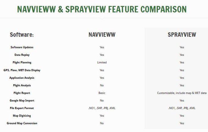
Along with its large range of navigation systems, application control devices and accessories, AG-NAV offers fully featured GIS software. We offer the premium SprayView as well as the free, basic NavViewW.
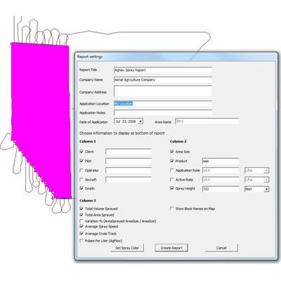
Create powerful flight reports
SprayView allows you to create powerful flight reports. With both SprayView and NavViewW, you can create a detailed flight data report with spray data. SprayViewW allows you to create additional reports which can be customized with the information you want, such as map or MET display.
Replay flight path and spray
From the office, you can visually review and analyze your flight and spray data by replaying it. Here you can see how well the job was done.
Full Google Integration
SprayView integrates fully with Google programs. Get an aerial overhead map from Google with the click of a button. Import KML files to use for future spray jobs. Export your flight and spray data to KML for direct 3D, high quality viewing with Google Earth.
Plan Your Flight
SprayView allows you to plan your flight in the office. Mark your corners, exclusion zones, and create optimized grid lines before stepping foot in the plane. No need to generate a spray area on-the-fly. A whole job can be planned ahead of time in office.
LIFETIME LICENSE
SprayView is licensed software. The license fee is paid only once. It`s your contribution to the maintenance and improvement of the software. Besides the software, you get free software updates and free technical support. And feel free to give AG-NAV your feedback and comments on what features are good for you.