

PipeAId - AI-Driven Sewer Inspection Tool
PipeAId is an AI-enhanced software tool designed to revolutionize the maintenance and operation of sewer systems. Utilizing advanced machine learning and computer vision, PipeAId automates the process of reviewing CCTV footage of sewer infrastructure, identifying and categorizing defects with precision. This digital assistant tool integrates with geographic information systems (GIS), providing utility professionals with a digital twin of their sewer network, complete with comprehensive data and visual insights for each pipe segment. The AI is continually improving through supervision by NASSCO-certified engineers, ensuring reliability even for atypical defects. By transforming video inspections into actionable data, PipeAId offers utilities the capability to make informed decisions, effectively prioritize repairs, and optimize their asset management budgets. It also provides significant cost reductions and faster delivery of results compared to conventional inspection methods. PipeAId demonstrates enhanced accuracy through its training on millions of linear feet of pipes, guaranteeing a thorough defect identification process.
A Powerful AI Tool for Sewer Rehab and Operations
For communities across the country, sewer systems are often the least visible and most expensive asset to maintain. PipeAId™ is a digital assistant tool that uses AI (artificial intelligence) to identify, code and record defects in sewers, making sewer camera inspection considerably easier and more accurate
When PipeAId is activated, defects are tagged with their precise location in a geographic information system (GIS). This data helps utilities prioritize repairs, manage assets and stretch maintenance and repair budgets.
AI reviews CCTV (closed-circuit television) video to flag defects and create a digital map of your sewer network. Because engineers are supervising the tool, PipeAId becomes more knowledgeable every time it is applied. When a more obscure “non-learned” defect is observed, it is flagged for a NASSCO-certified engineer (National Association of Sewer Service Companies) to code and the software to learn.
- Step 1 : CCTV is collected for sewer assets
-
Step 2 : PipeAId identifies, codes and records defects
-
Step 3 : NASSCO trained engineers supervise the tool
-
Step 4 : GIS database developed to map sewer conditions and prioritize repairs
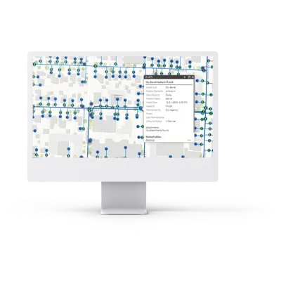
PipeAId is delivered on an advanced GIS platform that includes a digital twin of the collection system. The digital twin shows the condition of each pipe segment and geospatially locates each observation with images attached that provide detailed information. Paired with our data hosting solution, the digital twin also links the inspection video to each pipe segment so that staff can access it in the field or in the office by simply clicking on the pipeline segment.
This innovative solution provides utility owners with the detailed data they need to make informed decisions about their systems’ needs. PipeAId’s streamlined approach also delivers results in less time and at a fraction of the cost of traditional assessments.
-
The condition of each pipe segment.
-
It geospatially locates each observation with detailed information.
-
Links the inspection video to each pipe segment.
A Better Tool for Use with Sewer Inspection Cameras
PipeAId delivers cutting-edge sewer AI technology integrated with GIS. Our AI-powered digital assistant tool enhances sewer video inspection by automating parts of the inspection and coding process, and by removing human error from the equation.
Why Use PipeAId?
PipeAId is trained on millions of lineal feet of pipe and identifies the most common NASSCO defects with 90% accuracy. That is better than the most experienced technician on their best day. The platform retains information, so the data can be used to predict failures based on deterioration trends over time. It can also help demonstrate compliance with EPA consent decrees, validate rate structures to ensure appropriate revenue is being collected to cover future repair costs and aid in responding to resident concerns.
PipeAId Capabilities
This software has been designed by a nationally recognized sewer engineering team. It can upload, review and deliver data with any type of input and video format, coded or not, as long as it includes length of pipe. Once the data is collected it is turned over to clients, with cloud hosting services available as needed.
Improve Visibility
Improve visibility of buried assets, which are the most expensive assets for a utility
Increase Confidence
Increase confidence in utility planning decisions
Road Map
Provide a road map by adding defects into a GIS to take the guesswork out of which repairs are necessary and how to prioritize them
Designed
Software designed by engineers
Any Video Format
Review sewer inspection data in any video format, as long as it includes length of pipe