

IMMIS - Air Quality Models
Supplying IMMIS to local, regional and federal authorities as well as consulting companies, IVU Umwelt provides a comprehensive program set to evaluate traffic induced air and noise pollution.
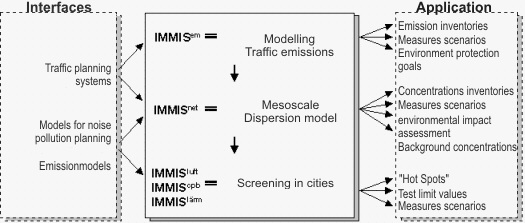
The program system IMMIS consists of the following programs:
- IMMISem - is developed to calculate traffic-induced emissions
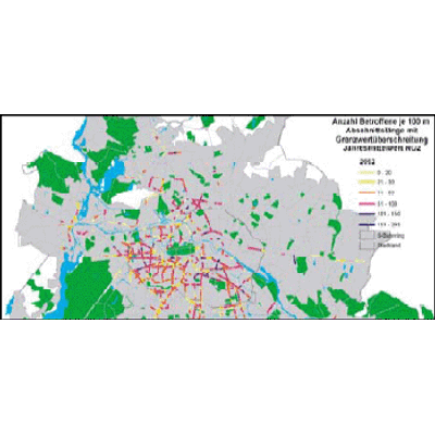
- IMMISnet - a Gaussian multi-source dispersion model is used to calculate and represent the spatial extent of background level concentration of air pollution
- IMMISluft (air) - is a Screening program for the evaluation of air pollution in city streets
- IMMIScpb - for the calculation of complex individual case studies and short term calculations of air pollutant`s transmission in street canyons
- IMMISlärm (noise) - for the estimation of noise pollutions in street canyons
- IMMISmap und IMMISarc - the integration of the IMMIS modules into the geographical information systems (GIS) MapInfo and ArcView, respectively
Environmental Traffic Management
With the possibility to determine the impact of traffic on air quality within streets in real time, IMMISmt can be used to extend traffic control leading to an optimised, environmental sensitive traffic management. If defined pollution levels are reached, IMMSmt can e. g. issue warnings initiating traffic control measures. IMMISmt can monitor the effect of the applied control measures on the entire road network. Operated in simulation mode, IMMISmt can be used to assess the effects of intended control scenarios, thus offering important assistance in the search for suitable and effective control measures.
Modules and Scalability
IMMISmt consists of several modules that can be combined according to specific requirements. Due to its design, IMMISmt can be connected to a variety of data interfaces (e. g. OPCI) within existing IT-infrastructures. IMMISmt is scaleable, thus able to process data for a few streets as well as extensive road networks of lager cities or conurbations. Within IMMISmt, all input and output data is stored in a database. Depending on specific requirements, the database can be both file-based or a client/server database management system.
Visualisation
Results like traffic emissions, background and street concentrations or noise levels can be displayed with the IMMISmt-Viewer software or be published using a web mapping service for a cartographical representation in the internet and/or intranet.
Reporting and Analysis
As all data is stored in a database, it can be used directly for reporting or analyses, e. g. of statistical parameters, not requiring advanced investigation or external expertises.
The lagrangian dispersion model LASAT, developed and distributed by Ingenieurbüro Janicke, is being employed by IVU Umwelt GmbH in addition to IMMISnet to calculate pollutant dispersion. LASAT is a complex model for calculating concentrations of air pollutants, taking into account e. g. orography and building structures. It is based on the same algorithms as AUSTAL2000 and is in accordance with the new German directive on air pollution modelling TA-Luft.
In studies for large areas with many emission sources, the generation of input data in the required formats is often tedious. The use of a GIS for the automatic generation directly out of GIS-data is practically indispensable. Therefore, IVU Umwelt has developed the ArcView-Extension LASarc.
The current release LASarc 2.0 offers the following functionalities:
- set calculation parameters in dialog
- set pollutant parameter in dialog
- selection and definition of the gridded domain using shape and grid files automatic
- creation of mandatory intermediate grids in case of grid nesting
- cross-project transformation of coordinates for LASAT input and output files to ensure LASAT-compliant coordinate values (e. g. when using GK-coordinates)
- conversion of shape files in LASAT-source files, controlled by the user`s specification of important parameters and unit conversion
- automatic conversion of IMMISluft/em-databases into LASAT input files, including the conversion of specific emission data and unit conversion
- automatic conversion of LASAT results into ESRI-shape files for arbitrary, user defined parts of the investigated domain; conversion of relative and absolute errors is available
- call of LASAT calculations from within ArcView
LASarc 2.0 is available for ArcView GIS 3.x. An ArcGIS 8 extension is being developed.
More detailed information on is available on the Ingenieurbüro Janicke home page.
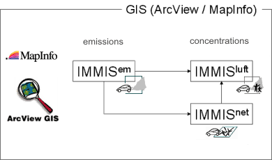
IMMISem, IMMISluft and IMMISnet:
The combination of the models provides the maintenance of background, additional and total concentrations of one dataset in one general database.
All street data are stored in one central dBase-File according to specifications of IMMISluft. The entire processing is carried out from within ArcView GIS and MapInfo, respectively, thus allowing direct visualization and additional processing of the results.