

Meniscus Systems Ltd - Part of METASPHERE
Meniscus - Version MAP Rain -Analytics Platform Software
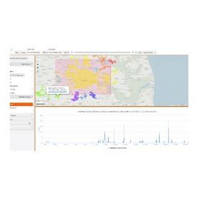
MAP Rain is our high performance, flexible and scalable cloud-based solution for rainfall and flood monitoring analytics. MAP Rain delivers location specific rainfall analytics for any point and any area of interest. Uses machine learning to predict the impact rainfall has on assets
Most popular related searches
flood alarm
flood monitoring
river level
rain gauging
hydraulic modeling
rain gauge
asset monitoring
rainfall monitor
mapping system
integrity monitoring
- Monitor actual and predicted rainfall at any location and receive e-mail alerts for any high values
- Calculate historic rainfall calculations i.e. Antecedent Precipitation Index API
- Connect to the simple Flood Monitoring Dashboard directly from any monitored point
- Apply simplified hydraulic models to any catchment to predict the impact that rainfall will have on that catchment
- Create your own catchment polygon (s), or store existing ones, and access historic aggregated rainfall for that catchment
- Calculate Rainfall Return Periods (FEH99, FEH2013 and Bilham) for any historic, or forecast, rain event
- Combine real time radar and forecast rainfall into one dataset – so all calculations use both historic and forecast rainfall
- Display river level and rain gauge data from Environment Agency gauging stations
- Readily integrates with packages like R to carry out bespoke statistical analysis
- Integrate data directly into your applications using the MAP API – used to build MAP Rain dashboard
- Choose from a range of alerts and customise threshold values
- Use machine learning to predict performance of assets in wet weather