

Esri
Most popular related searches
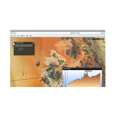
With ArcGIS Explorer, you can
- Access ready-to-use ArcGIS Online basemaps and layers.
- Fuse your local data with map services to create custom maps.
- Add photos, reports, videos, and other information to your maps.
- Perform spatial analysis (e.g., visibility, modeling, proximity search).
- Easy and intuitive to use—it`s easy for anyone to begin working with ArcGIS Explorer, with its intuitive and easy to use ribbon user interface that presents tools in the context of how you use them. Tools including integrated tool tips and Help.
- Choose your Basemap—The Basemap Gallery allows you to choose from a variety of ready-to-use basemaps so you can get started quickly. Select from ArcGIS Online basemaps such as World Imagery, World Streets, World Topographic Maps, or choose a Bing Map service (Aerials, Hybrid, and Roads). You can also create your own basemaps and add them to the Gallery. Toggle basemaps on the fly while maintaining your operational layers.
- Add local data such as geodatabases, shapefiles, KML/KMZ, GPX, and raster formats (JPEG 2000, GeoTIFF, MrSID). You can also add layer files and packages created using ArcGIS for Desktop, or add locations from your spreadsheets.
- Access a wide variety of mapping services from ArcGIS for Server; ArcIMS; and Open Geospatial Consortium, Inc. (OGC) WMS, and GeoRSS feeds.
- Integrate a wide variety of content such as photos, videos, documents, and more and place them in a geographic context.
- Integrated 2D and 3D Display—Switch display modes with a single click. View maps and globes in any projection or coordinate system.
- Extend ArcGIS Explorer using Add-Ins and the Analysis Gallery. Extend the core capabilities using geoprocessing tools and models published using ArcGIS for Server, or connect to a wide variety of other available services.
- E-mail your maps and layers directly from the application. See a demo [WMV].
- Communicate geographically using Presentations—A unique and powerful feature of ArcGIS Explorer, presentations allow you communicate geographically using live data and and services. Answer geographic questions and share the answers with others.
- Customize ArcGIS Explorer using centrally managed application configurations with no programming required. Control functionality and add your own tools, and customize the look and feel of ArcGIS Explorer to meet the needs of specific users or workflows in your organization. You can also use the free, downloadable software development kit (SDK) to create new add-ins.
- Fully localized—ArcGIS Explorer is fully localized, including all user interface elements and Help. Choose from English, French, Japanese, Chinese, German, or Spanish.
- Find more resources—Visit the online Resource Center for a one-stop place to access online help, blogs, and samples
ArcGIS Explorer Desktop 2500 includes the following enhancements:
- Ability to easily upload GIS content directly to your ArcGIS Online account
- Added support for ArcGIS Online and Portal for ArcGIS sharing, roles, custom basemap galleries, and organization-specific search
- Capability to display attribute tables for feature layers
- Presentation tools such as slide animations, timed transitions, audio synchronization, and presentation mark up
- ArcGIS Explorer Desktop can be run off of an external USB connected drive on any computer that meets the ArcGIS Explorer Desktop system requirements.
- Size and position of popup windows can be controlled
- Support for KML tours
- Ability to use custom locators