


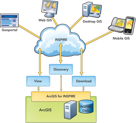
ArcGIS for INSPIRE
The INSPIRE directive sets out a framework and timetable for sharing spatial data within the European Community to help address pan-European issues in a multinational and multiagency spatial data infrastructure (SDI). ArcGIS provides a powerful and comprehensive SDI solution that now includes capabilities to ensure INSPIRE compliance supporting data, services, and metadata, which are delivered in the new ArcGIS for INSPIRE.
ArcGIS for INSPIRE helps meet INSPIRE compliance in a timely manner by extending the ArcGIS software that already exists in your organization. It provides
- INSPIRE View Service
- INSPIRE Download Service
- INSPIRE Annex I data models
- INSPIRE Discovery Service
ArcGIS for INSPIRE helps meet compliance in a timely manner by extending your existing ArcGIS software to provide
- An ArcGIS for Desktop extension to create and maintain INSPIRE-compliant geospatial data and metadata.
- An ArcGIS for Server extension to serve INSPIRE-compliant View and Download services.
- INSPIRE-compliant geodatabase templates for extracting, transforming, and loading (ETL) geospatial information from existing databases into INSPIRE-compliant geodatabases.
- The open source Esri Geoportal Server and Add-ons to catalog and index INSPIRE-compliant metadata and to serve INSPIRE compliant Discovery services.
The Infrastructure for Spatial Information in Europe (INSPIRE) is a directive passed by the European Commission, the executive body of the EU, to establish a European-wide spatial data infrastructure (SDI). Its goal is for an Internet-accessible infrastructure of technologies and permissions to tie European geospatial information producers and users together into a single geospatial information-sharing community to improve decision making and operations in service of a productive and sustainable Europe.