

- Home
- Companies
- Planetek Italia s.r.l.
- Software
- Rheticus Safeland - Automatic ...
Rheticus Safeland - Automatic Cloud-Based Geoinformation Services
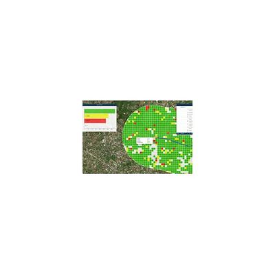
Automatic cloud-based geoinformation service for subsidence, landislide and ground motion monitoring and analysis over time. Supporting risk mitigation and prevention activities to safeguard infrastructure, buildings and citizens. Monitoring is essential to assessing and predicting landslides or ground structural weaknesses, which could affect buildings or infrastructures. To get accurate information over areas subject to subsidence or slow moving landslides, in order to anticipate potential risks, is fundamental for geological services, organizations and professionals working in civil protection, master plan management, engineering and insurance companies.
Rheticus® Safeland is an automatic cloud-based geoinformation service designed to deliver periodically fresh and accurate satellite-based data and information to help Authorities and professionals monitoring ground surface movements.
The service provides continuous monitoring of areas subject to:
- landslides,
- natural- and/or human-induced subsidence in urban and suburban areas,
- stability of infrastructures (e.g. dams, bridges, buildings, road and railway networks, pipelines, electric towers, solar and wind farms, and so forth).
Using European Copernicus Sentinel-1 open data or COSMO-SkyMed data images and persistent scatterers techniques, the service is complementary to traditional survey methods, providing a long-term solution to ground instability monitoring.
- Governmental Institutions in charge of urban planning and land monitoring, infrastructure monitoring, civil protection in case of landslides and/or subsidence phenomena, and so forth;
- Stakeholders within Engineering and Management Companies of Utilities networks, Oil&Gas, Electric Power, Renewable Energy, Mining, and Construction Industries as well as within Insurance, Business-to-Customer, Real Estate, Stock Exchange sectors;
- Scientific Communities and NGOs.
Timely identification of critical subsidence phenomena and landslides, optimization of on site monitoring activities, planning of emergency maintenance interventions.
Key Benefits
- Timely information is provided automatically at affordable prices
- Maps, reports and indices are actionable and available 24/7 from different platforms and devices
- Saves time and resources normally dedicated to data search and processing and information production
- Data and results are standardized and comparable over time