

BlueConduit - Management Tool for Assembling Water-System-Wide
We are incredibly excited to announce that Google.org will support BlueConduit, through the BlueConduit Charitable Fund, to develop software tools aimed at locating dangerous lead pipes and removing them from water systems across the United States. This new freely available product will be designed to maximally benefit cities that seek to address the challenge of lead in water infrastructure.
It will be built on top of the BlueConduit Platform and will feature several core components, including:
- A data management tool for assembling a water-system-wide service line inventory
- Statistical and machine learning tools for estimating the quantity of lead pipes in a water system, their distribution, and the costs and time commitments required for remediation
- Transparent reporting of known and unknown inventory data to the public and regulators, designed to be used in submissions of funding requests to state and federal authorities
- A public-facing “nationwide LSL replacement report card” that maps the progress of the lead service line remediation across the US
These tools and offerings are scheduled for initial release during the first half of 2022. We are thrilled with the support from Google.org, the developing partnership with NRDC and WE ACT, and the fiscal sponsorship from the Windward Fund! To learn more about the project check out our blog.
There’s a lot of uncertainty when it comes to inventorying service lines. BlueConduit applies sound statistical principles to characterize these uncertainties and guide water systems in their compliance and replacement programs.
This data-driven approach helps water systems accurately budget their replacement programs, as well as target their excavations at homes with highest probability of lead. Read our case studies to learn more.
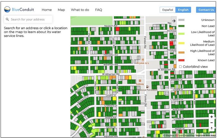
BlueConduit can also translate this data into publicly available maps to educate residents about their own lead risk and keep them informed of the replacement program’s progress.
We begin with a rigorous review of existing service line and parcel data to generate estimates of the total number of lead service lines in the system and create the framework of a predictive model to make statistically valid home-by-home probabilities. We then select an iterative representative set of homes for the city to inspect the complete service line, using cutting edge statistical methods to target addresses that will reveal the most information to aid development of the model.
The representative sample will combine with existing data to generate predictions about the likelihood of a lead service line at each address. To best inform municipal decision-making, we can organize the results at the neighborhood or block level. Guided by the actionable data, the city can carry out digs and replacements, which then further updates the model with new information so that it can learn and improve its predictions.

Since the summer of 2019, BlueConduit has brought its methodology for inventorying and locating lead service lines to more than 50 towns and cities, regularly achieving hit rates of greater than 70% in replacement projects, thereby saving substantial time and money.
Many towns and cities do not have reliable data on the number or location of lead service lines in their water systems. This makes it difficult to plan budgets, perform lead service line inventories, comply with state and federal regulations, or communicate with the public.
BlueConduit’s machine learning model provides water systems with actionable home-by-home lead service line predictions so that they can efficiently carry out inventory and replacement programs. We partner with water utilities, cities, and engineering consulting firms to do this.

BlueConduit recognizes the equity and justice considerations of public health and infrastructure burdens. We regularly partner with foundations to make sure that our work is accessible to all communities.
hazardous infrastructure in need of replacement
efficiently by targeting highest risk areas
communities to establish trust, be transparent, and protect public health
Neighborhood and household level risk identification for hazardous infrastructure.
Maps for program management and community engagement.
Inventory tracking and monitoring for EPA compliance.