

- Home
- Companies
- Trinity Consultants
- Software
- BREEZE AERMET - Process Meteorological ...

BREEZE AERMET - Process Meteorological Data
BREEZE AERMET 7 simplifies the process of creating AERMOD-ready meteorological data files from raw data formats. Combining full U.S. EPA regulatory compliance with an all-new user interface, BREEZE AERMET 7 is both more powerful and easier to use than ever.
- Includes the latest U.S. EPA executables: AERMET 16216 and AERMINUTE 15272
- Integrates raw 1-minute wind data automatically with the new AERMINUTE utility
- Improves the network dongle efficiency
- Follows modern Microsoft user-interface design standards that make AERMET processing intuitive
- Hover over any checkbox, button, or blank for tooltips with helpful basic guidance and hints to help avoid common errors
- Converts U.K. ADMS model data into AERMOD-ready format
- Processes a wide range of surface and upper air data types: ISHD (TD-3505), CD144, HUSWO, SAMSON, SCRAM, TD3280, ADMS, TD-6405 (1-minute ASOS), FSL, TD-6201
What`s New in 7.8
- Incorporates the latest U.S. EPA AERMET executable 16216 released on December 20, 2016
- Fixes a bug that may cause wrong sunrise hour determination when the on-site meteorological data file provides the mixing height parameter and the upper air data are not used in AERMET processing
Regulatory Compliance
- Includes the latest U.S. EPA executables: AERMET 16216 and AERMINUTE 15272
- Imports AERSURFACE files directly, making compliance with standard U.S. EPA land-use practices easy
- Choose between letting AERMET calculate land use for you or manually inputting land use values into the redesigned Land Use interface, helpful for international users and U.S. users with state-specific land use requirements
- Integrates raw 1-minute wind data automatically with the new AERMINUTE utility
- Uses modular design to allow quick software updates when U.S. EPA model changes are released
- Automates data quality checks with Quality Assurance tab
Ease of Use
- Improves the network dongle efficiency
- Follows modern Microsoft user-interface design standards that make AERMET processing intuitive
- Hover over any checkbox, button, or blank for tooltips with helpful basic guidance and hints to help avoid common errors
- Automatically checks every value you enter for basic mistakes.
- Accidentally enter your longitude value in the latitude blank? AERMET 7 will highlight it in red to let you know something isn’t right.
- Find the information you need with extensive, updated Help and in-program access to EPA user guides
- Find and resolve problems in your AERMET runs easily with report and error/warning message displays
- Supports on-site data in simple space-, tab-, or comma-separated value formats (Fortran FREE format)
- Stores all project files in one ZIP file so you keep track of one file with everything in it instead of dozens of files
Power and Flexibility
- Converts U.K. ADMS model data into AERMOD-ready format
- Processes a wide range of surface and upper air data types: ISHD (TD-3505), CD144, HUSWO, SAMSON, SCRAM, TD3280, ADMS, TD-6405 (1-minute ASOS), FSL, TD-6201
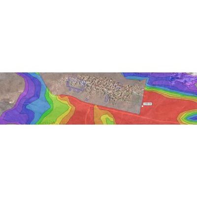
- Includes MetView tool to help you evaluate/QAQC both raw and AERMOD-ready met data, visually and in table format
- Allows AERMET to be applied worldwide, not just in U.S., thanks to Sunrise-based sounding selection (subject to availability)
- Adjust land use characteristics easily without setting up a full AERMET job with “Merge-only” mode feature
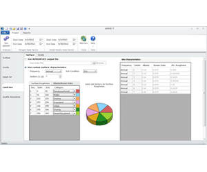
Surface Data
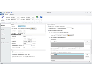
The Surface tab in AERMET 7 allows surface data, typically from government weather stations, to be read in to AERMET. This includes 1-minute (AERMINUTE) wind data, which can easily be imported. When you specify a surface data file, AERMET will find the station in its internal database and fill in fields such as latitude and longitude automatically.
AERMET 7 supports a large number of surface meteorological data formats. Many standard archive formats, from the modern TD-3505 (ISHD) format to SAMSON, HUSWO, CD-144 (Card Deck 144), SCRAM, and TD-3280. Additionally, AERMET 7 provides the unique capability to import meteorological data formatted for the ADMS model, making comparisons between AERMOD and ADMS easy. Additionally, AERMET 7 combines the ability to read ADMS files with a mixing height estimation algorithm that allows AERMOD-ready data to be prepared even in parts of the world (such as the U.K.) that do not have the morning upper air sounding that AERMOD normally requires.
AERMINUTE and 1-Minute Wind Data (TD-6505) Integration
The AERMINUTE preprocessor, introduced in 2011, added a new level of sophistication and complexity to AERMOD meteorological data processing. With BREEZE AERMET 7, you can import your raw data and let AERMET 7 run AERMINUTE seamlessly for you or you can import an AERMINUTE output file from a previous run. Either way, adding 1-minute wind data to your project can be done with a few clicks.
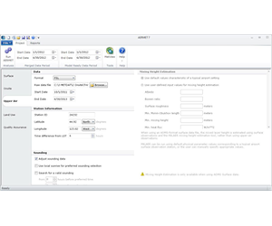
Upper Atmosphere Data
The Upper Air tab allows the user to quickly import data from an upper atmosphere sounding station, which is typically required in order to produce AERMOD-ready met data. Like the Surface tab, when you select your upper air data file in the Upper Air tab, AERMET 7 will save you time by automatically filling out fields such as latitude and longitude.
Support for Non-U.S. Applications
AERMET 7 includes several features designed to make it easier to generate AERMOD-ready meteorological data for non-U.S. locations. For areas such as Asia and South America that have the near-sunrise-time upper air observations needed by AERMOD, AERMET 7 allows the user to specify a window centered on the local sunrise time in which to search for data. For areas such as Western Europe that do not have near-sunrise observations, AERMET 7 can use a combination of ADMS data and a proprietary mixing height algorithm to produce AERMOD-ready data without the need for upper air observations at all.
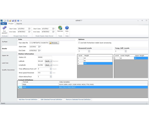
On-site Station Data
In addition to typical surface and upper air data, usually from government-operated weather stations, AERMET 7 can import a wide range of meteorological data collected at on-site stations. These range from data from meteorological towers that measure wind and temperature at multiple heights to SODAR and wind profiler data. AERMET 7 includes support for the Fortran FREE format, meaning data exported from spreadsheet software like Microsoft Excel can easily be read in.
Land Use Data
The Land Use tab provides a simple and flexible way for AERMET to get the important information it needs on the characteristics of the land surface that surrounds their meteorological station.
Many U.S. AERMET/AERMOD users are required to use the AERSURFACE utility to automatically calculate the proper land use characteristics for their site. AERMET 7 gives users the ability to directly read in AERSURFACE output files – simply run AERSURFACE via its straightforward question-and-answer format and then point AERMET 7 to the location of your output file. Everything else is handled by program.
AERMET Custom Land Use CalculatorAERMET 7 provides another simple method for providing land use information through its custom surface characteristics calculator. Rather than worrying about Bowen ratios and albedo values, simply provide basic information on the area surrounding your site (e.g. forest to the north, open fields to the south) and let AERMET do all of the hard calculations for you.
Use Your Own MethodFor users who have their own preferred methods for calculating land use characteristics, AERMET 7 accommodates you too: a simple spreadsheet interface allows you to do your own calculations outside of AERMET and then copy surface roughness, Bowen ratio, and albedo values directly in to AERMET 7.
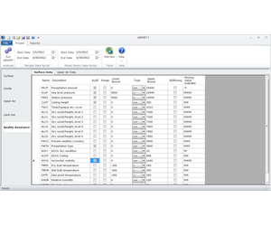
Quality Assurance Tools
In addition to setting up and running AERMET, producing a trustworthy meteorological dataset for AERMOD requires thorough Quality Assurance/Quality Control (QA/QC), including finding the root causes of error/warning messages, evaluating the accuracy of unusual data values, and ensuring that the final .SFC and .PFL files that will be used in AERMOD contain reasonable values. AERMET 7 provides a number of tools to make this easier.
BREEZE MetView Basic is included in AERMET 7, and can be launched (with your current data files open and ready for review) from a button in AERMET 7. From determining the number of calm and missing hours in your dataset to checking solar radiation values to make sure you used the correct time zones, MetView makes reviewing and examining both raw and AERMOD-ready meteorological data easy.
Reports tab and Error ListAs soon as your run completes, AERMET 7 will automatically bring up an Error List that puts all advisory, warning, and error messages produced by the AERMET executable at your fingertips. In seconds you can assess whether there are any potential issues with your run and if so, what they are. For more detailed QA/QC, the redesigned Reports tab allows you to view and save all input, output, and report files, and is organized by AERMET Stage to make it easy to determine just where in the AERMET process an issue may have come up.
Quality Assurance ChecksAn important component of any AERMET run is ensuring that the meteorological data are of high quality and that any poor-quality data is rejected. The Quality Assurance tab in AERMET 7 makes it easy to incorporate these checks into your AERMET job. Users can specify which variables to QA/QC, as well as controlling options such as what upper and lower bounds to allow for each variable.
Single-File Project Storage
AERMET processing can involve dozens of files: surface, on-site, 1-minute, upper air, and land use input files as well as a host of output and report files. AERMET 7 simplifies things by storing all of this data in one .ATZ zip file, making it easy to collaborate with co-workers or submit a file to a regulatory agency. Want to send someone just one particular file from your project? You can save individual files to a separate text file in AERMET 7, or you can unzip the entire .ATZ file to access all of the component files individually.
Hardware
- Intel or AMD processor, 32-bit or 64-bit. 500-megahertz (MHz) or higher
- 256 megabytes (MB) RAM, 512 MB RAM recommended
- 100 (MB) available disk space for the application install. Meteorological data files may require significantly more
- 1280 x 1024 minimum display resolution
- Mouse or other pointing device
Software
- Windows 10, Windows 8, Windows 7, Windows Vista, Windows Server 2003, Windows Server 2008 or Windows Server 2012
- Microsoft .NET Framework 4.0 or later
Additional Requirements
- Raw meteorological data for surface, upper air and/or onsite data sets