

- Home
- Companies
- Trinity Consultants
- Software
- BREEZE AERMOD/ISC - Air Quality ...
BREEZE AERMOD/ISC - Air Quality Dispersion Modeling System
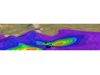
AERMOD is a steady-state Gaussian dispersion model that represents the current state-of-science and promulgated dispersion model from the U.S. EPA. BREEZE AERMOD is an enhanced version of the EPA-approved AERMOD that provides modelers with the tools and functionality required to perform air quality analyses that help to address both permitting, regulatory, and nuisance issues as well as perform academic research. BREEZE AERMOD/ISC offers the most complete air quality modeling system available on the market today. No other application is used by more air quality professionals around the world.
AERMOD Pro
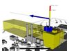
BREEZE AERMOD Pro is loaded with features to optimize your modeling. The intuitive user interface is extremely easy to learn and understand, and guides users through the model setup and analyzing results. With BREEZE AERMOD Pro, users have access to a variety of displays (e.g., 3D view, time series view, etc.), data entry options (e.g., importing a base map, copying and pasting to a table from Excel, CAD drawing tools), data processing options, model outputs, and plotting and data manipulation/analysis tools. Additionally, significant effort has gone into giving users the option to hide many of the data entry options that they might not require. For example, if you are not modeling deposition, you can choose not to show the data entry options related to deposition. These advanced features included in BREEZE AERMOD Pro are very beneficial for new and seasoned users, and increase productivity by adapting to the users preferences and workflow.
A basic, merge-only version of BREEZE AERMET and a basic version of BREEZE MetView come standard with BREEZE AERMOD Pro.
Price: $1,495.00
AERMOD Pro Plus
BREEZE AERMOD Pro Plus includes all of the features of the Pro edition, as well as a handful of additional features mainly pertaining to data manipulation/analysis and animation graphics. For example, BREEZE AERMOD Pro Plus provides users with a distribution view and a contribution view option, which users can utilize to determine the distribution and contribution of each source over a given time period. Additionally, with BREEZE AERMOD Pro Plus, users have the ability to create a variety of animations (e.g., map, 3D, cross-section, contribution chart, distribution chart, and Google Earth contour animation) that they would not have access to with the Pro edition. These animations are great visual tools when presenting results to colleagues or clients. Other enhanced performance features that are included in the Pro Plus edition but not the Pro edition include the ability for users to:
- Export to Shapefiles
- Plot to scalable vector graphics
- Combine multiple post-processed POST files into a single file
- Merge plot files
- Merge post files
- Export data to XYZC, VTK, and XYC formats
- Interpolate dynamic inter-node
- Create a data flowchart
A basic, merge-only version of BREEZE AERMET and a basic version of BREEZE MetView come standard with BREEZE AERMOD Pro Plus.
Price: $1,995.00
BREEZE AERMOD/ISC is available in two editions: Pro and Pro Plus. BREEZE AERMOD Pro is suitable to conduct complete full air dispersion modeling analyses and reporting. The Pro Plus edition offers additional features and functionality to increase efficiency as well as advanced post-processing and results tools.
What`s New in 8.0
- Implements downloading of high-resolution base maps for any locations around the world
- Enables selecting and converting imported DWG/DXF objects to AERMOD model objects and buildings
- Facilitates automated generation of discrete receptor arrays around model objects
- Adds a source tool to simultaneously assign particle deposition parameters or gaseous deposition parameters to a group of sources
- Facilitates automated generation of discrete receptor arrays around model objects
- Preserves compatibility with U.S. EPA AERMOD versions 15181, 14134, 13350, 12345, 12060, 09292, and 07026
Basic Features
- Incorporates the latest U.S. EPA AERMOD executable 16216r released on January 17, 2017
- Adds BREEZE-enhanced version of the latest AERMOD executable 16216r
- Enables high-speed parallel and BREEZE versions of the latest AERMOD executable 16216r
- Includes a basic, merge-only version of BREEZE AERMET and a basic version of BREEZE MetView
- Streamlines graphical user interface for more intuitive and easier dispersion modeling
- Incorporates a feature that automatically imports a geo-referenced base map file with certain data file format
- Adds a feature to generate an aligned or geo-referenced file after manually importing a base map and geo-referencing it
- Imports 2D and 3D geometric data with AutoCAD`s .dwg/dxf file formats
- Simplifies the setup of pre-modeling objects with a variety of utilities
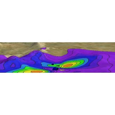
- Analyzes post-modeling results using BREEZE 3D Analyst, tables for sensitive receptors, and 3D visuals for surface terrain
- Organizes model scenarios using a skeleton and neat file structure for better file management
- Uses inputs that are consistent and compatible with U.S. EPA AERMOD inputs, including test cases in U.S. EPA SCRAM website
Technical Features
- Streamlines NO2, SO2 and PM2.5 modeling for U.S. NAAQS
- Adds a feature to allow applying an in-stack NO2/NOx ratio to multiple sources all at once for all source types
- Incorporates the Ambient Ratio Method (ARM) and ARM2 for NO2 modeling
- Adds a new tool to facilitate users to calculate buoyancy parameters for buoyant line sources
- Models an unlimited number of sources and receptors
- Models numerous source types including point/stack (vertical, horizontal and capped), area, volume, open pit, flare, BREEZE area line and EPA area line
- Models numerous receptor types including discrete Cartesian grid, polar grid, and variable density grid
- Models multiple emission scenarios simultaneously
- Models an unlimited number of buildings with integrated BPIP analysis and downwash
- Utilizes CAD drawing tools
- Supports 7.5 DEM, 1 minute DEM, XYZ, and NED terrain data files
- Uses historical, hourly meteorological data with single or multiple hours
- Includes BREEZE AERMOD Parallel and Remote Parallel modeling option
- Includes ISC model
Parallel Processing
To combat the increased runtimes observed with EPA’s AERMOD, BREEZE created a parallel processing version to slash runtimes through the use of a distributed computer network (cluster) or multi-CPU environment. Our high performance applications produce pollutant concentration estimates identical to EPA’s Fortran executable. The only code changes to the application are additions to implement parallel features. The applications run the exact algorithms but on different processors.
There are two deployment options available for BREEZE AERMOD to users interested in parallel processing— local and remote resources. A two-core local parallel processing version is included in BREEZE AERMOD.
The local approach involves purchasing parallel software and determining how many processors are desired to run the software application. Improvements in the product’s performance enhancements are based directly on the number of CPUs (or cores) utilized. If a new octo-core computer is not in the budget, a computer cluster can simulate a single multi-core computer.
RemoteAlternatively, the BREEZE Remote Modeling System requires no proprietary software and runs on a massively parallel computer cluster managed by BREEZE Software. Users upload input files anytime (24/7), receive email notifications when model results are completed, and slash model runtimes up to 100 times faster!
U.S. EPA EquivalencyBREEZE developed AERMOD Parallel to significantly improve performance across multiple processors. As part of the product development process, equivalency testing was performed with hundreds of AERMOD model runs using both the AERMOD Fortran executable and the BREEZE AERMOD Parallel executables. Based on all completed test cases, modeling results generated by the BREEZE AERMOD Parallel are identical to those generated by the U.S. EPA AERMOD executables.
Assigning the model ready historical meteorological data in BREEZE AERMOD is easy. Simply select the files to use with a particular scenario. BREEZE will identify the period that the data set is valid for and display the station ID so that there are no mistakes setting up the input file. BREEZE MetView, a companion product, interprets model results from the meteorological point of view.
A number of options are available from BREEZE AERMOD to refine the period of meteorological data to process, such as ‘Start/End period’ option, ‘Day range’ option, and ‘All hours’ option, so users do not need to split the meteorological files when performing modeling for a particular period.
BREEZE MetViewBREEZE AERMOD links with MetView for seamless transition from one program to the next. MetView displays the data in both tabular and chart format. You can also create wind roses for user defined periods. This feature allows users to simultaneously view and interpret model results using corresponding meteorological data.
BREEZE AERMOD allows you to model the standard U.S. EPA sources (i.e., point, area, volume, open pit and EPA area line) and exclusive BREEZE sources such as flare and BREEZE area line sources. In addition, BREEZE offers object array generators that create user defined arrays (e.g., polylines, polygons, and Cartesian grids) of the model object type. Source elevations can also be processed with the embedded U.S. EPA AERMAP program.
BREEZE AERMOD processes flare sources as equivalent point sources according to U.S. EPA modeling guidance. It calculates the equivalent source diameter internally according to user defined parameters, such as hear release, radiation loss, and exit velocity.
Multiple Methods to Add SourcesBREEZE AERMOD gives you the option to run the standard U.S. EPA version of AERMOD or a BREEZE enhanced version which offers numerous features not available anywhere else, including a multi-scenario version that models multiple emission scenarios in the same amount of time it takes to model a single pollutant. In addition, BREEZE AERMOD allows you to run your model using a previous U.S. EPA version of AERMOD.
AERMOD takes into account the obstruction of wind flow from structures, such as buildings and point sources (i.e., stacks). Like any other model object in BREEZE AERMOD, buildings can be copied and pasted or drawn into the 2D display. Building information can be processed with the embedded U.S. EPA BPIP Prime program.
BREEZE AERMOD offers you the ability to create rectangular, circular, and polygon buildings. A simple building mode is an exclusive feature of BREEZE AERMOD that eliminates the error prone requirement of assigning "tier levels" to each and every structure.
BREEZE Downwash AnalystBREEZE offers the Downwash Analyst Software as a data analysis tool that takes the cryptic numerical results of AERMOD’s BPIP building pre-processor and displays them in the clearest way possible.
Receptors are locations where BREEZE AERMOD will compute a concentration or deposition value. At least one receptor must be defined. Receptor elevations can also be processed with the embedded U.S. EPA AERMAP program.
BREEZE AERMOD offers you the ability to create discrete, gridded, and polygon arrays. BREEZE AERMOD also has the exclusive ability to generate variable density and 3D gridded networks.

BREEZE AERMOD provides a variety of tools to facilitate the setup of model or the analysis of results.
- Ozone file, hourly emission file, and AERMOD input file editors
- XYZ2DEM Utility to convert XYZ terrain files to digital elevation model (DEM) format
- Coordinate Converter to convert one coordinate to another
- AERMET, 3D Analyst , and MetView access if they are pre-installed
- BRMS merger to merge BRMS results which can then be read by 3D Analyst
- Blank on-site or off-site receptors tool
- Import tool to import model objects from existing scenarios
- Export tool to export model objects to DXF files
- Data Explorer to view project data in a Windows Explorer-like fashion
- Spreadsheet or Table view allows model object data to be viewed, added, removed, and edited in a Windows Excel-like fashion
- Map window to import DXF files, shape files, or base map images as well as visualize model objects
- 3D window to view buildings and terrain
- TerraServer access to download base maps
- Access and help from AERMOD experts in the BREEZE Support Team
 |
 |

ISC Model
BREEZE AERMOD suite includes the Industrial Source Complex (ISC) short-term model. ISC predicts pollutant concentrations from nearly any type of source emitting non-reactive pollutants. It allows you to define receptor grids and consider topographical features for each receptor location. You are also able to input above ground-level heights to simulate the impact at elevated or “flagpole” receptors. BREEZE ISC also predicts pollutant concentrations from: point, line, area, volume, and flare sources with variable emissions in all terrain regimes.
In December 2006, AERMOD replaced ISC as the U.S. EPA recommended regulatory model. ISC is still widely used internationally.

- Intel or AMD processor, 32 or 64 bit. 500-megahertz (Mhz) or higher
- 256 megabytes (MB) RAM, 512 MB RAM recommended
- 2 gigabyte (GB) available disk space
- 1024 x 768 minimum display resolution
- Mouse or other pointing device
- 3D features require a video card that supports DirectX 9
- Windows 10, Windows 8, Windows 7, Windows Vista, Windows Server 2003, Windows Server 2008 or Windows Server 2012
- Microsoft .NET Framework 4.0 or later
- None