

Comprehensive GIS-Based Information- and Planning System
With FOG you will get a comprehensive GIS-based information- and planning system, which operates within urban drainage (with HYSTEM-EXTRAN) and urban flood management (with FOG 2D). As an extension for the geographic information system ArcGIS (ESRI), FOG meets all requirements for an efficient urban drainage planning. FOG 7 is also availabe in Chinese language.
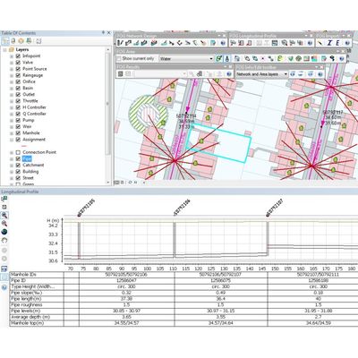
FOG allows the presentation of pipe network data in different views (maps, time series and longitudinal view) and the data processing with automated and manual tools. Height information can be taken from digital elevation models. Comprehensive tools for surface processing support the digitization and the quick link of detailed spatial information with the network data. To ensure the consistency of the surface data, powerful tools for topology checking and geometry repair are available too. The assignment of multiple areas to one pipe is possible.
FOG supports the transfer of data through open interfaces for importing ESRI ,CAD and MS Office formats as well as HYSTEM-EXTRAN databases. The analysis of simulation results can be simply made in longitudinal views, in curves derived from time-series and in theme plans. The use of ArcGIS labeling functions is will be simplified with a label editor.
The program is available with an optional module:
- FOG 2D
Urban flood management with the assessment of frequencies of flooding corresponding to DIN EN 752.
(FOG 7 is also availabe in Chinese language!)
- Import/export interface to HYSTEM-EXTRAN; import from ESRI, CAD and MS Office formats
- Editing of pipe networks with object-oriented data input or tools for moving, cutting, interpolation and multiple assignment
- Presentation of longitudinal views with manhole connections, crossing pipes, digital elevation and simulation results; working in longitudinal and plan view at the same time
- Topological clean editing of spatial data, tools for repairing geometry
- Automatical assignment of surface areas to the pipe network based on distance relationships; automatic creation of catchment areas using Thiessen-Polygons
- Individual runoff parameters for each site area can be considered
- Generation of numerate sewer networks; all parameters which are required for simulation can be set
- Display of hydrographs
- Preparation of theme plans
- Search and analysis functions, error checking of network data
- Function calls from topic related toolbars
- Easy creation of labels
All indications without engagement, subject to alterations.
- Create flood hazard map according to DWA-M 119
- Model decentralized rainwater management systems
- Determine quality criteria between measure data and simulation results
- Event balancing for every special structure type
- FOG support center for problem solving
- Areas with geometries within HYSTEM-EXTRAN database
- …and much more!