
- Home
- Companies
- Drone Harmony AG
- Software
- Drone Harmony - Flight Planning and ...
Drone Harmony - Flight Planning and Management Solution for the DJI Dock
Drone Harmony for DJI Dock is the most powerful flight planning and management solution for the DJI Dock, providing unprecedented situational awareness, planning, and visualization capabilities for your Dock sites. Plan, monitor & inspect in Full-3D with Drone Harmony and the DJI Dock.
The Most Advanced and Intuitive 3D Flight Management Platform for the DJI Dock
Based on Drone Harmony’s proprietary FULL-3D platform, Drone Harmony for DJI Dock provides unprecedented levels of control and visualization capabilities for the DJI Dock.
Drone Harmony for DJI Dock was designed with the highest levels of data security in mind. In particular, the solution can easily be installed on your server (on-premise) or a private network.
Drone Harmony is the only system that provides full live feeds from multiple DJI Docks combined with an intuitive 3D interface. Track in real-time any critical parameter of each of your active missions and DJI Docks overlaid over a realistic virtual site representing your asset.
Drone Harmony uniquely enables safe obstacle-avoiding flight planning based on custom 3D data and the unmatched ability to visualize the plans for review. Restrictions on executed flights can be imposed on user-defined no-fly zones and geofences.
Drone Harmony provides an industry-leading flight planning workflow with a combination of dozens of automated flight planning features with powerful plan adjustment tools. Planning features are tailored to address many use cases, including 2D and 3D mapping, terrain mapping, structure inspection, electric utility inspection, tower inspection, search and rescue, perimeter protection & patrol, solar inspection, methane detection, and more.
Drone Harmony’s image data support is uniquely designed to easily browse captured drone data. Images are sorted by time, date, dock, and flights. They are automatically geolocated and overlaid in Map and 3D views.
Drone Harmony is a true site management platform that manages multiple heterogeneous sites in one intuitive interface. Scaling your operations with Drone Harmony is as easy as adding a new site to your enterprise account.
Drone Harmony is the only solution for the DJI Dock that presents your DJI Dock sites in a FULL-3D environment, containing a rich variety of data types, from terrain models to point clouds.
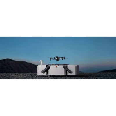
The DJI docking station is a sturdy and dependable solution that charges your drone in just 25 minutes. Equipped with active temperature control, it can conduct operations in all weather conditions, from stormy to sunny. With the ability to capture data on demand, the M30 Series Dock is the perfect choice for any aerial inspection or survey. It integrates wide, zoom, and thermal cameras (M30T only) with a laser rangefinder, putting all the target details you need at your fingertips.
Fast Charging, Fast Turnaround
Fast charge and take off thanks to TEC air conditioning that cools the drone batteries, enabling charging from 10-90% in just 25 minutes.
-35? to 50? Operating Temperature
DJI Docks are built to withstand the elements, so you don`t have to.
Full Live Feeds
Low-latency live feed from multiple DJI Dock M30T drones. Live telemetry views from all connected docks and drones. Status Bar displaying key information from all active docks.
Flight Monitoring and Control Features
Visual Monitoring of flight execution in Map and 3D views. Quickly Start, Stop, and Pause missions at any time.
Safety Features
No-Fly-Zones and Geofences for airspace control. Obstacle-avoiding flight plans are automatically computed based on Site data. Full 3D visualization of flight plans for intuitive flight review.
Flight Planning & Management
The richest 3D flight planning capabilities on the market. Unlimited number of missions in one site for quick deployment and repeatable workflow.
Various Supported Formats
Automated plans are tailored for imported data, including terrain, vector, and shape data (supported formats include Geotiff for terrain and surface models, KML/KMZ for shape data, Geotiff for custom maps, and more).
Image Data Management
Automated image data upload from the M30T drone and storage in Drone Harmony. Image Gallery: flip through images in order of capture. Images are automatically sorted by mission, date, dock, and flight.