

- Home
- Companies
- PetRos EiKon Incorporated
- Software
- Emigma - Version Premium Series - ...
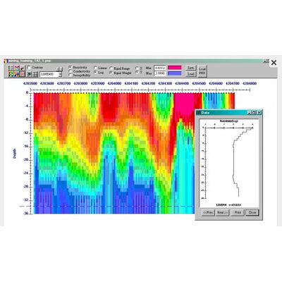
Emigma - Version Premium Series -Airborne FEM Software
The Airborne FEM software package also includes Ground FEM and is available as an add-on to other EMIGMA Premium licenses or as a standalone product. In the airborne FEM method, the transmitter and receiver coils are generally housed in a single case and are towed by a helicopter. Airborne FEM offers the advantage of collecting large amounts of data over a relatively short period of time. Being not limited by the geophysical survey size, EMIGMA allows rapid airborne FEM modeling and inversion. EMIGMA is an excellent tool for survey design as well as for interpreting measured data.
The package offers very good routines for calculating apparent resistivity as well as an adaptation of the Sengpiel section techniques. EMIGMA also allows you to process your FEM data (ground and airborne) through several 1D inversion tools and produce these as conductivity depth sections relative both to ground level and to actual GPS elevation.
Includes our Magnetics package for integrating magnetic data with your EM.
Data Import
- Calibrated data imports from ASCII files or manufacturer`s format, such as Ground Geonics EM31/34/34R/38, Max-Min, Geophex. Generally any dipole-dipole type system can be imported.
Data Processing and Correction
- 1D digital and spatial filters, 2D spatial filters
- Simple and weighted averaging decimation
- Data Corrector tool combining dynamic spreadsheets and line plotter for data cleaning, missing data interpolation and simultaneous plotting of different data channels for fast cross-analysis
- Profile Modifier Tool - Access your data from a survey perspective, edit your survey, create maps, clean your data
3D Modeling
- Fast and accurate 3D simulations: model suite generation and batch mode
- Unlimited prism, plate and polyhedra targets
Polyhedra: pipes (hollow cylinders with or without lids), ellipsoids, shells, bullets, landmines, drums, spheres, general polyhedra... - Multiple body interactions
- Modeling of topography effects
- Modeling of magnetic effects in EM data
- Ability to handle full contrast between host and bodies
- Incorporation of altitude information
- Interactive 3D model building tool
1D Inversion
- Multi-Component and/or Multi-Frequency inversions, Inphase/Quadrature or Quadrature only
- Three algorithms to choose from
- Smooth Occam resistivity inversion with fixed layer thickness
- Smooth Occam joint susceptibility/resistivity inversion with fixed layer thickness with user defined starting models
- Underparametrized Marquardt Inversions - invert for thickness and/or resistivity
- User defined starting models
- User defined parameters for inversion
- Full resistivity and thickness constraints
- Spatial smoothing capabilities
- Suite of minimization techniques
- Incorporation of GPS_Z information
CDIMAP
- Apparent Resistivity Tool - a half-space mapping technique for generating apparent resistivities as a function of frequency
- Sengpiel Depth-Sections - a resistivity pseudosection technique for generating resistivities as a function of pseudo-depths
Data Display and Analyses
- Display of data over flight altitude variations, GPS positions
- Display of Apparent Resistivity as a surface or spatial contour
- PEXShow tool - 2D representation of geoelectric sections
- Display of 3D models sliced and diced in the 3D Visualizer
- Grids: Natural Neighbor, Delauney Triangulation, Shepard & True-to-Data, Minimum Curvature and Thin-Plate-Splines
- Contours: 2D and 3D surfaces
- Line plots
- Residual plots
- For more detailed data display capabilities, see EMIGMA Complete
Data Export
- Export to postscript files, raster or GeoTIFF formats
- Export to XYZ ASCII file (containing station, position, depth and apparent resistivity) to allow for the geoelectric sections to be utilized in other plotting or printing applications such as Geosoft or Surfer
EMIGMA made its appearance more than 22 years ago as a prompt-based 3D forward electromagnetic modeling program that has developed into a state-of-the-art comprehensive geophysical interpretation platform. Today it offers versatile solutions for electromagnetic, gravity, magnetic, magnetotelluric, induced polarization, resistivity, and CSAMT applications integrating data processing, simulation, inversion and imaging software as well as other associated tools.
Your data collected or even just guessed - this is where the power of EMIGMA starts. You either import your raw data using various import procedures designed to meet your very specific demands. EMIGMA is smart enough to recognize the type of your data, survey configuration and channel information and offer you an intelligent choice in the case of any ambiguity. Or, you create your model from scratch. EMIGMA provides a comprehensive interface to make this task easy and fast. You are automatically taken through all the necessary steps until your model is ready to be viewed and subject to forward simulation and inversions. EMIGMA`s data display package includes 3D visualization, plotting, gridding, contouring, grid analyses and spatial data analyses. All of these tools are fully equipped and easily managed. Coupled with your intuition, they may provide invaluable assistance in the process of data interpretation.
EMIGMA`s features are designed to satisfy every imaginable requirement of our customers. Being highly sophisticated, the platform can boast a clear and logical structure, friendly interface and fast operation speed.
Relevant links