- Home
- Companies
- Transect Inc.
- Software
- Transect Reports - Environmental Due ...
Transect Reports - Environmental Due Diligence Reports Software
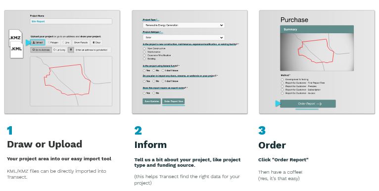
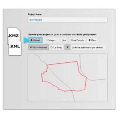
Right now, you are paying thousands of dollars and waiting days upon days to have your proposed project sites professionally evaluated for environmental red flags. Not any more! Now, you can generate on-demand, in-depth, and highly-accurate environmental desktop reports with just a few clicks.
Say goodbye to static, expensive environmental desktop reports.
Get on-demand due diligence reports with just a few clicks using Transect Report’s comprehensive analysis.
Transect Reports have an interactive map where you can explore & download all of the environmental data found on your project site. But a map is only useful if you know how the data will impact to your project. So, every Transect Report also has...
Site-specific analyses of the data on your project with expert insight into how environmental constraints will impact your project footprint, budget, and schedule.
An easy-to-digest comprehensive overview of key environmental topics highlighting a high, medium, or low concern level based on onsite data, project context, and the regulatory setting.
Transect searches our database of 1,000+ permits and pathways to determine which permits are required for the project area.
Each Transect Report includes a list of applicable permits, a description of what triggered the permit, links to permit applications, permit timelines, and recommendations for next steps, like an onsite survey or agency coordination.
Transect Reports have the most comprehensive online source of species regulatory and location data.
We have detailed profiles on more than 2,500 species at 600,000 sites. Data resolution ranges from USFWS ECOS county ranges down to known element occurrences.
Our data partnerships in multiple states ensure local and national species are accounted for. We combine our data with a site-specific habitat analysis to ensure that you know exactly which protected species may occur on your project.
Including wetlands, streams, floodplains, and navigable waterways.
We’ve categorized 37,000,000+ waters and more than 1,300,000,000 acres of floodplains in 11 zones. We use this data to tell you exactly which federal and state waters-related regulations and permits could affect your project.
Including EPA registered facilities, protected & tribal lands, soils, geology, parcels, transmission lines, substations, railroads, mines, landslide areas, elevation, and thousands of other site attributes that could affect your project footprint, schedule, or timeline.