Transect Vision - Environmental Mapping Software for Site Selection
The Ultimate Environmental Prospecting Tool for Site Selection. Choose the Right Site the First Time. When it comes to site selection, having instant access to environmental data at a landscape level can take your due diligence from days of searching for data or weeks of waiting on consultants... to just a few seconds.
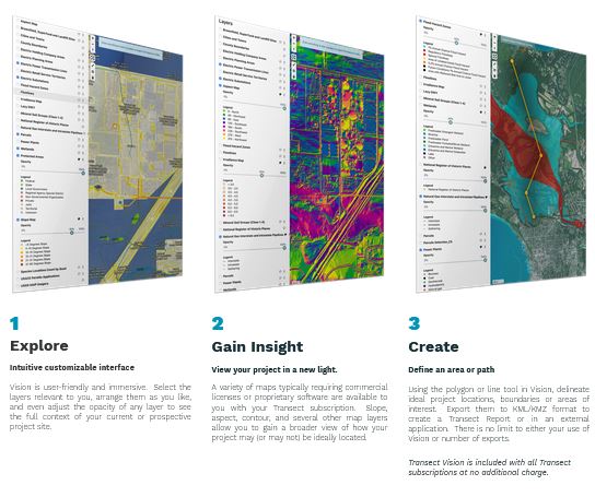
What does Transect Vision Look Like?
Our high-quality, user-friendly, and customizable mapping can bring your entire team into the site selection process.
Vision’s mapping software comes standard with 8 base maps and 18 data layers, or customize it for your company.
Get easy, fast insight into:
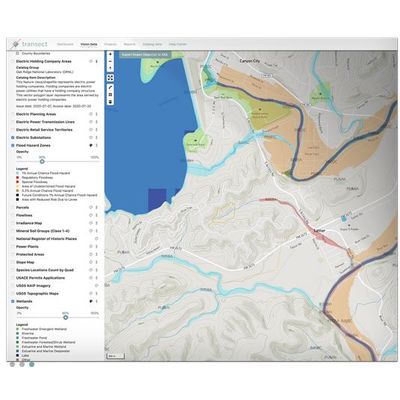
Includes brownfield, superfund, and landfill sites, protected lands, soils, National Register of Historic Places, cities and towns, irradiance data, and more.
We’ve built nationwide elevation, slope, and aspect maps for you to toggle through.
Find the right property parcel for your project. We have 95% coverage in the US.
Includes wetlands, rivers, floodplains, and navigable waterways.
We’ve categorized 37,000,000 waters and more than 1,300,000,000 acres of floodplains. Plus, see USACE permit applications near you.
With data profiles for over 2,500 species, find out if your site may be near or in the vicinity of a protected species of concern.
We have more than 36,000 miles of transmission lines with 21 unique data attributes, and more than 62,000 substations. Plus power plants, airports, electric retail service areas, pipelines, and more.