

Discover - Exploration GIS Software
The ever-popular Discover exploration software is now compatible with two of the industry leading GIS platforms MapInfo Pro and ArcGIS Pro. Both versions are fully integrated with the must-have field mapping app Discover Mobile. Discover for MapInfo Pro is an Exploration focused product, assisting the exploration professional in their daily activities from data conversion, map making to field work. Discover is bundled with the industry leading MapInfo Pro tools we all know, and domain focused exploration functions.
Exploration geologists acquire data from a multitude of sources and in a variety of formats. Data conversion and transformation is paramount to a speedy workflow. MapInfo Pro and Discover can import most spatial formats and industry specific data types and export back into these formats. From the rich range of available import and export formats, MapInfo Pro and Discover will simplify your daily tasks.
Discover is packed with vast array of analytical tools such as GraphMap, Data Classification, Correlation Matrix, Hydrological Analysis and Geophysical surface grid filters. These are just a subset of the available analytical tools. Whether it’s vector, image or surface datasets Discover has a tool to analyse and enrich your data.
MapInfo Pro and Discover have all the annotation tools for creating professional quality map outputs. Scalebars, titleblocks, map grids, map adornments, labels along with the popular and easy to use Scaled Layout tool for simple production of scaled templated maps.
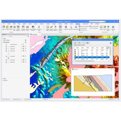
Convert your drilling data collected in the field into spatially correct cross sections. The drillhole module contains all the tools for displaying and analysing your geophysical, assay and lithological downhole data. Want to plan your next drilling campaign, Discover has all the tools for laying out your traverse lines and all the subsequent analysis. To complement your drillhole data is the ability to display in Discover 3D.