

Farmers Edge Inc.
- Home
- Companies
- Farmers Edge Inc.
- Software
- Farmers Edge - High-Frequency Satellite ...
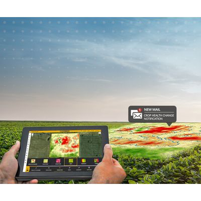
Farmers Edge - High-Frequency Satellite Imagery
Combining unique map layers and automatic health change detection, Farmers Edge provides timely, field-level insights for your broadacre crops. With imagery processed within 48 hours, Farmers Edge technology goes beyond the industry standard to help you detect and respond to issues before yield is impacted.
Most popular related searches
- Imagery Derived Map Layers
- Automatic Crop Health Change Detection
- Advanced Scouting Technology
- Depict a consistent view of fields to help track crop growth and vegetation productivity
- Unique map layers draw out finer variability in the field to pinpoint areas for scouting
- Identify issues that may impact yield such as irrigation irregularities, spray applications and equipment malfunctions
- Powered by high-resolution imagery and rapid data processing for fast problem detection
- Imagery from within 14 days is compared and scanned to identify any changes in the field
- Health Change Maps and Notifications are automatically generated when a change takes place within the field
- Area of change is outlined on the field to enhance scouting efficiency
- Helps identify potential yield threats such as pests, diseases, nutrient deficiencies, lodging, damage from weather events and more
- Automatic syncing keeps all records in one place
- Locate problem spots accurately with GPS navigation
- Access built-in pest lists, take pictures and schedule tasks right from the field