

SeisWare - Field Development Planning Software
Geoscientists are making million dollar drilling decisions from disconnected data and rudimentary well sticks. SeisWare incorporates all your geoscience data and engineering information into realistic 3D pad designs so that you can focus on production instead of fighting your software.
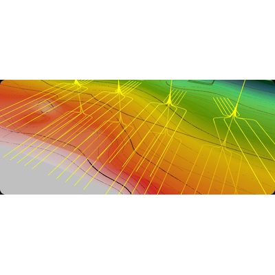
Create well plans in 30 mins vs. one day. Our design process incorporates 3D geoscience data so that you and your team can get up and running faster.
Ditch the well sticks and complex 2D workflows. Calculate realistic pads & well paths and incorporate rich subsurface data to optimize costs and production.
Share information with the view-only tool instead of exporting the data and rebuilding the display.
Dial-up design. Ditch the back-and-forths. Ensure drillability.
Geologists and geophysicists are making multi-million dollar drilling decisions from disconnected data and rudimentary well sticks. SeisWare helps geoscience and asset teams develop and plan future development efficiently and economically.
- Customize each well within a pad for more precise adjustments.
- Manage build and turn rates to ensure drillability.
- Adjust kickoff points and laterals for realistic paths.
- Lock laterals and adjust surface pad locations for optimal design.
- Create pad templates based on identified targets.
- Specify parameters like well number, spacing, and lateral characteristics.
- Define azimuth, build, and turn rates for optimal well design.
- Assess pad placement feasibility while considering land, sub-surface, surface, and infrastructure constraints.
- Clip laterals within land boundaries with user-defined offsets.
- Use templates to place multiple pads within full-field scenarios.
- Determine hydrocarbon recovery potential and associated technical and financial risks.
- Ensure thorough analysis for sustainable development.
- Create and compare multiple development scenarios, computing and displaying statistics for both well pads and full fields.
- Determine the most economically viable and sustainable plan through comprehensive scenario analysis.
- Use lateral length statistics to calculate reserves accurately.
- Estimate probable recoverable resources with precision.
- Share 3D views of pad and field development plans with asset team members and managers in real-time.
- Build current and future plans in 3D using any desktop.
- Easily access the Well Planning Viewer to view results and evaluate what-if scenarios without requiring a planning license.
- Foster cost-effective collaboration by purchasing the viewer at a lower cost compared to a full license. This enables teams to make decisions more easily and efficiently.