

- Home
- Companies
- ForeFlight
- Software
- ForeFlight - Version Mobile - Aviation ...
ForeFlight - Version Mobile -Aviation App
On the ground and in the air, pilots worldwide depend on ForeFlight Mobile for flight planning, charts, weather, airport information, document management, flight logging, synthetic vision, and more.
ALL THE VFR & IFR CHARTS YOU NEED
VFR and IFR charts from the FAA, NAV CANADA, EUROCONTROL, as well as other sources to give you everything you need for any type of flying.
GLOBAL VECTOR AERONAUTICAL MAP
Find useful information at every zoom level with this customizable, data-driven map layer, complete with embedded airport diagrams.
INTERACTIVE MAP LAYERS
Get the full picture with dozens of interactive map layers for weather, hazards, surface maps, fuel prices, and imported custom content.
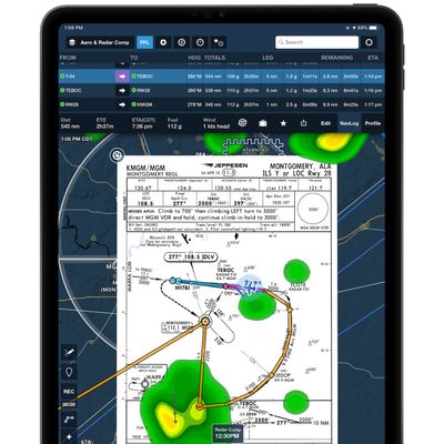
PROCEDURES & TAXI CHARTS
SIDs, STARs, and geo-referenced approaches and taxi charts help you find your way in the air and on the ground.
View global forecast wind speed, direction, and temperatures at multiple altitudes and times using these stunning animated weather layers. Both the “Winds (Temps)” and “Winds (Speeds)” layers use colorful heat maps covering the globe to represent their primary forecast values at the selected altitude and time. Overlaid on each layer’s heat map are smoothly-flowing particle animations representing wind direction and speed, providing an intuitive view of large-scale weather patterns in relation to the layer’s primary forecast value (wind speed or temperature). Use the Time Slider to view wind forecasts in a 24+ hour period, and move the Altitude Slider to view winds from the surface up to 63,000 ft.
Both layers are included with ForeFlight Performance subscription plans.
Enable U.S. or Global Icing and Turbulence layers using the new layer selector in 3D Preview to display forecast weather along your route. 3D View depicts forecast weather as floating colored blocks that use the same color scale to represent forecast severity as the overhead map and Profile View. Use the altitude slider on the right to view weather at different altitudes, and tap the RTE button at the top of the altitude slider to only show weather at the same altitude as your route.
Weather in 3D Preview is included in ForeFlight’s Performance Plus plans.
In partnership with FlightAware, stream live global aircraft traffic directly in ForeFlight to analyze airport activity, check on an active flight, and more. ForeFlight displays both airborne and ground traffic received via the internet just like it does ADS-B traffic, with altitude and tail number available at a glance, and many other details available with a tap for most traffic targets.
Write and draw directly on ForeFlight’s map for easier and more convenient note taking. Tap the Annotations button on the left side of the screen to enter Drawing mode. Annotations show up above any Map or Layer and you can easily undo, redo, and clear notes, as well as change the ink and brush properties.
Jeppesen`s worldwide library of charts are available as an option in all ForeFlight Mobile subscription plans, making it your all-in-one solution for planning, briefing, filing, flying, and logging flights.