

I•GIS
GeoCloud - Geo-Data Management Platform
FromI•GIS
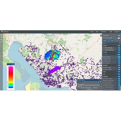
GeoCloud serves as an advanced platform for the management and visualization of geoscience data, providing a centralized location for storing geological models. Utilizing cloud-based infrastructure, GeoCloud promotes effortless sharing and collaboration of data across geographical boundaries. It features seamless integration with GeoScene3D, allowing direct access to geo-modeling projects through a web interface. Users can view data using visualizations such as 2D GIS maps and dynamic 3D viewers. The platform's architecture is designed to improve workflow efficiencies while preventing data loss. GeoCloud offers flexible pricing, with tailored options available to meet unique organizational needs, making data management both scalable and customizable. The GeoCloud Learning Center provides resources such as video tutorials and online support to help users maximize its capabilities.Most popular related searches
geoscience data
geological modeling
GIS mapping
geoscience
data visualization
utility infrastructure
geographic data
infrastructure data
geological data
The perfect online platform for storing and sharing your valuable geo-data.
GeoCloud offers a centralized platform for managing, visualizing, and accessing your geoscience data and geological models. With a cloud-based infrastructure, it facilitates seamless data sharing and collaboration.
GeoCloud revolutionizes how you manage, store, and utilize your geoscience data by enhancing efficiency and preventing data loss from neglected storage or overlooked drives. It facilitates seamless collaboration on models, data sharing across geographical boundaries and streamlines workflows by reducing time spent on data conversion. This will allow you to concentrate on other productive tasks.